| Mesoscale Discussion 1445 | |
| < Previous MD Next MD > | |

|
|
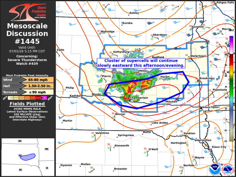
Mesoscale Discussion 1445 NWS Storm Prediction Center Norman OK 0341 PM CDT Thu Jul 02 2026 Areas affected...east-central South Dakota Concerning...Severe Thunderstorm Watch 439... Valid 022041Z - 022215Z The severe weather threat for Severe Thunderstorm Watch 439 continues. SUMMARY...A cluster of supercells will continue slowly eastward this afternoon and evening. DISCUSSION...Very large hail (up to 3 inches) and brief tornadoes have been reported with the supercell that began in Brule county and has moved slowly northeastward. The tornado threat will likely remain as this supercell moves along the stalled outflow boundary. The cluster of supercells from the west is moving eastward quickly and will likely overtake this supercell within the hour. Additional convection to the south (with a recent measured 69 mph wind gust) indicates the potential for additional development and some upscale growth. If this occurs and the cluster accelerates east/southeast, watch 439 may need to be expanded. ..Bentley.. 07/02/2026 ...Please see www.spc.noaa.gov for graphic product... ATTN...WFO...FSD...ABR...UNR... LAT...LON 44200004 44359866 44499818 44539736 44269715 43999740 43749821 43589904 43669967 43960022 44200004 MOST PROBABLE PEAK TORNADO INTENSITY...UP TO 90 MPH MOST PROBABLE PEAK WIND GUST...65-80 MPH MOST PROBABLE PEAK HAIL SIZE...1.50-2.50 IN |
|
|
Top/All Mesoscale Discussions/Forecast Products/Home |
|
Source link