| Mesoscale Discussion 1429 | |
| < Previous MD | |

|
|
Mesoscale Discussion 1429
NWS Storm Prediction Center Norman OK
0611 PM CDT Wed Jul 01 2026
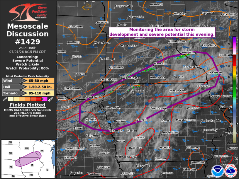
Areas affected...Northeast NE...northern IA...southern MN...western
WI...and far southeast SD
Concerning...Severe potential...Watch likely
Valid 012311Z - 020115Z
Probability of Watch Issuance...80 percent
SUMMARY...The area is being monitored for thunderstorm development
and an increasing all-hazards severe risk. While timing/evolution of
the severe risk remains uncertain, current thinking is that a watch
will be needed.
DISCUSSION...The latest visible satellite imagery indicates a
ENE/WSW-oriented band of gradually deepening boundary-layer cumulus
along a subtle surface boundary/confluence zone extending from
southern MN into northwest IA and vicinity. Over the next couple
hours, a strengthening southerly LLJ and related isentropic lift
should reduce remaining inhibition (sampled by the OAX 18Z sounding)
and promote widely scattered thunderstorm development along/near the
boundary. A warm/moist PBL (lower/middle 70s dewpoints) beneath
steep lapse rates is yielding strong surface-based buoyancy, which
combined with around 40 kt of effective shear, will favor storm
organization/intensification. Given the increasing warm advection
and boundary-parallel deep-layer shear, a mixed mode of supercells
and organized clusters will pose a risk for severe/damaging wind
gusts, large hail, and a couple tornadoes (given increasing
clockwise-curved low-level hodographs).
While the subtle forcing for ascent casts uncertainty on overall
convective timing/evolution, current thinking is that a watch will
be needed for parts of the area.
..Weinman/Thompson.. 07/01/2026
...Please see www.spc.noaa.gov for graphic product...
ATTN...WFO...ARX...MPX...DMX...FSD...OAX...
LAT...LON 44469322 44659194 44589123 44389095 43769060 43349083
42599326 42149444 41699613 41769697 42019768 42649767
43029706 44469322
MOST PROBABLE PEAK TORNADO INTENSITY...85-110 MPH
MOST PROBABLE PEAK WIND GUST...65-80 MPH
MOST PROBABLE PEAK HAIL SIZE...1.50-2.50 IN
|
|
|
Top/All Mesoscale Discussions/Forecast Products/Home |
|
Source link