| Mesoscale Discussion 1422 | |
| < Previous MD Next MD > | |

|
|
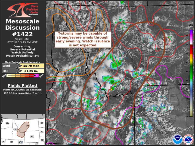
   Mesoscale Discussion 1422
   NWS Storm Prediction Center Norman OK
   0242 PM CDT Wed Jul 01 2026

   Areas affected...Portions of Idaho and Montana

   Concerning...Severe potential...Watch unlikely

   Valid 011942Z - 012145Z

   Probability of Watch Issuance...5 percent

   SUMMARY...Isolated strong to severe wind gusts will be possible as
   thunderstorms overspread portions of northeast Idaho and
   southwest/central Montana. Watch issuance is not expected.

   DISCUSSION...Lightning counts have been trending up across northeast
   ID and southwest MT over the past hour as an upper wave begins to
   shift east and temperatures warm into the upper 60s/low 70s. A
   combination a modest low-level moisture and cold temperatures aloft
   are supporting MLCAPE values on the order of 500 J/kg, which may
   increase slightly through late afternoon as daytime heating and some
   degree of mid-level ascent/cooling continues. Downstream of the
   developing convection, low-level lapse rates have steadily increased
   to around 8 C/km, which should support some potential for
   accelerating downdrafts and strong/severe downburst winds.
   Additionally, 25-30 knot mid-level flow sampled by the KSFX VWP
   suggests that some degree of cell organization is possible and may
   support a transient threat for large hail as well as severe gusts.
   In general, this potential should remain sufficiently isolated to
   preclude watch issuance.

   ..Moore/Guyer.. 07/01/2026

   ...Please see www.spc.noaa.gov for graphic product...

   ATTN...WFO...BYZ...RIW...TFX...PIH...MSO...BOI...

   LAT...LON   48220995 48020915 47630882 47170875 46640886 46210917
               45760969 45271025 44521097 43641118 43181139 42901187
               42821252 43221399 43491447 43761470 44191478 44581474
               45261440 46081349 47931138 48151082 48220995

   MOST PROBABLE PEAK WIND GUST...55-70 MPH
   MOST PROBABLE PEAK HAIL SIZE...UP TO 1.25 IN
|
|
|
Top/All Mesoscale Discussions/Forecast Products/Home |
|
Source link