| Mesoscale Discussion 1400 | |
| < Previous MD | |

|
|
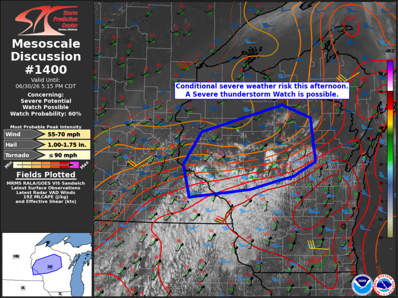
   Mesoscale Discussion 1400
   NWS Storm Prediction Center Norman OK
   0251 PM CDT Tue Jun 30 2026

   Areas affected...Southeast Minnesota into Central and Northern
   Wisconsin

   Concerning...Severe potential...Watch possible

   Valid 301951Z - 302215Z

   Probability of Watch Issuance...60 percent

   SUMMARY...A conditional risk for severe thunderstorms capable of
   mainly large hail and damaging winds appears to be materializing
   across the discussion area this afternoon. Convective trends are
   being monitored for a possible Severe Thunderstorm Watch.

   DISCUSSION...Recent trends in visible satellite indicate a deepening
   cumulus field along the nose of richer low-level moisture return
   from the Rochester, MN, area into central WI, near Marshfield. The
   shallow near-surface moisture profile observed by the 18z GRB
   sounding is likely not representative of the boundary-layer
   structure in the vicinity of the growing cumulus, where latest
   objective analysis indicates MLCAPE of 3500-4500 J/kg with little to
   no remaining convective inhibition.

   In the absence of appreciable forcing for ascent and discernible
   low-level boundaries, it remains unclear whether any storms that
   initiate will become sustained and rooted within the strongly
   unstable boundary layer. On the condition that storm initiation and
   sustenance occur, the 18z GRB sounding sampled sufficient vertical
   shear for supercells with the initial hazard being large hail.
   Damaging wind potential would likely increase by late afternoon into
   evening as storms coalesce along a common cold pool.

   ..Mead/Guyer.. 06/30/2026

   ...Please see www.spc.noaa.gov for graphic product...

   ATTN...WFO...GRB...DLH...ARX...MPX...

   LAT...LON   45908981 45648899 44748888 44468950 44339009 44209072
               44039244 44709263 45369211 45908981

   MOST PROBABLE PEAK TORNADO INTENSITY...UP TO 90 MPH
   MOST PROBABLE PEAK WIND GUST...55-70 MPH
   MOST PROBABLE PEAK HAIL SIZE...1.00-1.75 IN
|
|
|
Top/All Mesoscale Discussions/Forecast Products/Home |
|
Source link