| Mesoscale Discussion 1383 | |
| < Previous MD | |

|
|
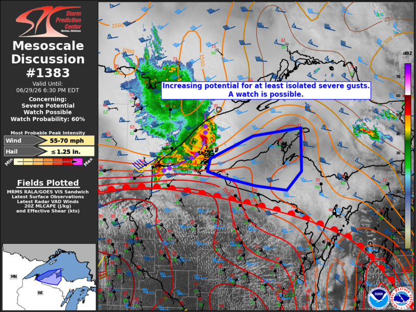
   Mesoscale Discussion 1383
   NWS Storm Prediction Center Norman OK
   0324 PM CDT Mon Jun 29 2026

   Areas affected...the Western U.P. of Michigan

   Concerning...Severe potential...Watch possible

   Valid 292024Z - 292230Z

   Probability of Watch Issuance...60 percent

   SUMMARY...The potential for at least isolated occurrences of severe
   wind gusts is expected to increase in the 2100-2130Z (4:00-4:30 PM
   CDT) time frame. A severe thunderstorm watch is possible.

   DISCUSSION...As of 2020Z, a long-lived bowing MCS was progressing
   through far western Lake Superior at around 45 kt. Extrapolation of
   the current motion takes it into the western U.P. of MI and adjacent
   near-shore waters between 2100-2130Z. The MCS is located to the
   north of a warm front lifting north through northern WI, suggesting
   that it might be slightly elevated atop a shallow near-ground
   inversion. Nonetheless, the presence of a strong rear-inflow jet
   will support the potential for at least isolated severe wind gusts
   late this afternoon into early evening.

   ..Mead/Guyer.. 06/29/2026

   ...Please see www.spc.noaa.gov for graphic product...

   ATTN...WFO...MQT...DLH...

   LAT...LON   46869061 47328936 47488796 46608794 46228838 46318927
               46469014 46609068 46869061

   MOST PROBABLE PEAK WIND GUST...55-70 MPH
   MOST PROBABLE PEAK HAIL SIZE...UP TO 1.25 IN
|
|
|
Top/All Mesoscale Discussions/Forecast Products/Home |
|
Source link