| Mesoscale Discussion 1381 | |
| < Previous MD Next MD > | |

|
|
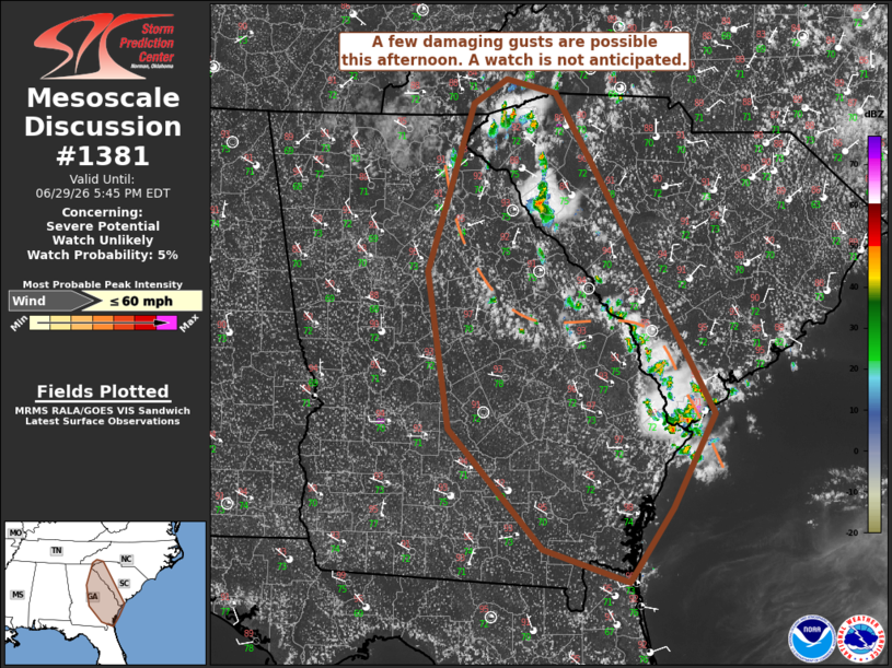
   Mesoscale Discussion 1381
   NWS Storm Prediction Center Norman OK
   0209 PM CDT Mon Jun 29 2026

   Areas affected...portions of western south Carolina and eastern
   Georgia

   Concerning...Severe potential...Watch unlikely

   Valid 291909Z - 292145Z

   Probability of Watch Issuance...5 percent

   SUMMARY...A few damaging gusts possible across portions of western
   South Carolina and eastern Georgia. A watch is not anticipated at
   this time.

   DISCUSSION...Convection is developing near the Georgia/South
   Carolina border at the periphery of an upper-level ridge. A deep,
   moist air mass is in place with weak flow throughout the column, as
   shown by the JAX 18Z RAOB. The weak flow is giving rise to mainly
   single-cell convection with occasional multicells, and a few weak
   downburst signatures have been observed on regional WSR-88Ds. Due to
   the moist profiles, some damaging gusts may occur with water-loaded
   downdrafts, and any clustering may increase the potential for
   damaging gusts. Additionally, a weak surface boundary may provide a
   focus for additional convection as the afternoon progresses.
   However, the coverage of damaging gusts is expected to be sparse
   enough that a watch is not anticipated at this time.

   ..Supinie/Guyer.. 06/29/2026

   ...Please see www.spc.noaa.gov for graphic product...

   ATTN...WFO...CHS...CAE...GSP...JAX...FFC...TAE...

   LAT...LON   32188057 34478189 35198233 35328289 35108326 33528375
               32058351 30928248 30618152 31308104 32188057

   MOST PROBABLE PEAK WIND GUST...UP TO 60 MPH
|
|
|
Top/All Mesoscale Discussions/Forecast Products/Home |
|
Source link