| Mesoscale Discussion 1379 | |
| < Previous MD Next MD > | |

|
|
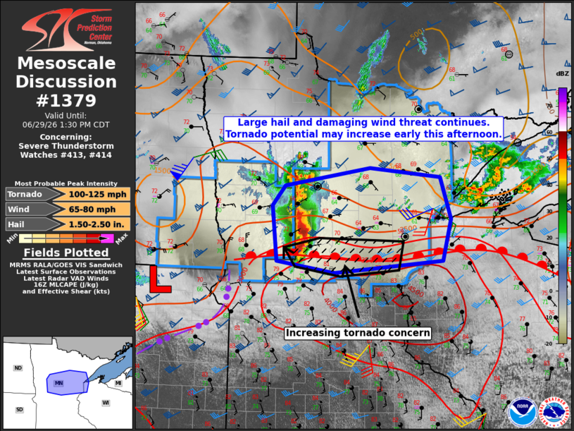
Mesoscale Discussion 1379 NWS Storm Prediction Center Norman OK 1137 AM CDT Mon Jun 29 2026 Areas affected...parts of Northern and Central Minnesota Concerning...Severe Thunderstorm Watch 413...414... Valid 291637Z - 291830Z The severe weather threat for Severe Thunderstorm Watch 413, 414 continues. SUMMARY...The threat for severe wind gusts and large hail will continue with a long-lived bow echo. Tornado potential may increase this afternoon within the southern fringe of the convective system as it interacts with a warm front. DISCUSSION...A long-lived bow echo over Wadena and Todd Counties as of 1630Z has assumed more of an easterly motion over the past hour owing to storm development/propagation on the southern fringe of the convective system. That propagational component has resulted in the storm system now moving parallel to a warm front lifting north through the region. The air mass south of the warm front has become strongly unstable with the modification of the 12z MPX sounding for current surface conditions yielding MLCAPE as high as 4500-5000 J/kg. The strong buoyancy coincides with 45-55 kt of effective bulk shear, per objective analysis with that parameter space supportive of the continuation of the bow echo, assuming the convection is fully rooted within the boundary layer. Damaging winds with gusts of 60-80 mph will remain the primary hazard; however, the potential for HP supercells to evolve within the broader-scale convective complex will support a large hail threat. The tornado threat may also increase this afternoon, especially with any supercell structures that can become established within the southern flank of the MCS in the vicinity of the warm front. ..Mead.. 06/29/2026 ...Please see www.spc.noaa.gov for graphic product... ATTN...WFO...DLH...MPX...FGF... LAT...LON 46059549 46879560 47169533 47419353 47279203 46669182 46069199 45889428 46059549 MOST PROBABLE PEAK TORNADO INTENSITY...100-125 MPH MOST PROBABLE PEAK WIND GUST...65-80 MPH MOST PROBABLE PEAK HAIL SIZE...1.50-2.50 IN |
|
|
Top/All Mesoscale Discussions/Forecast Products/Home |
|
Source link