| Mesoscale Discussion 1372 | |
| < Previous MD | |

|
|
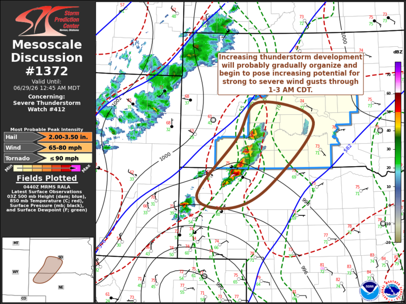
Mesoscale Discussion 1372 NWS Storm Prediction Center Norman OK 1143 PM CDT Sun Jun 28 2026 Areas affected...parts of northwestern Nebraska into central South Dakota Concerning...Severe Thunderstorm Watch 412... Valid 290443Z - 290645Z The severe weather threat for Severe Thunderstorm Watch 412 continues. SUMMARY...Increasing thunderstorm development probably will continue to grow upscale and begin to become better organized with increasing potential to produce strong to severe wind gusts, in addition to large hail, through 1-3 AM CDT. DISCUSSION...Strongest forcing for ascent associated with lower/mid-tropospheric warm advection is still developing across the Nebraska Panhandle into areas of South Dakota to the southeast of the Black Hills. However, this is forecast to begin shifting north-northeastward, across and north of the western Nebraska and South Dakota state border area through 06-08Z. As it does, ongoing convective development is likely to continue to to increase and organize, particularly as convective outflow consolidates and propagates northeastward, within 30-40 southerly deep-layer mean flow. As it does, strengthening north-northeasterly updraft inflow emanating from a moist unstable boundary-layer increasingly characterized by lower 70s F dew points may begin to support notable further intensification with increasing potential for strong to severe wind gusts, in addition to large hail. ..Kerr.. 06/29/2026 ...Please see www.spc.noaa.gov for graphic product... ATTN...WFO...ABR...LBF...UNR...CYS... LAT...LON 43610236 44430171 44000003 42600137 42120256 42390353 43610236 MOST PROBABLE PEAK TORNADO INTENSITY...UP TO 90 MPH MOST PROBABLE PEAK WIND GUST...65-80 MPH MOST PROBABLE PEAK HAIL SIZE...2.00-3.50 IN |
|
|
Top/All Mesoscale Discussions/Forecast Products/Home |
|
Source link