| Mesoscale Discussion 1363 | |
| < Previous MD | |

|
|
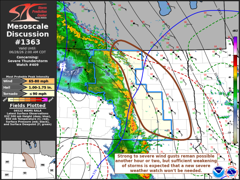
Mesoscale Discussion 1363 NWS Storm Prediction Center Norman OK 1155 PM CDT Sat Jun 27 2026 Areas affected...parts of central into eastern North Dakota Concerning...Severe Thunderstorm Watch 409... Valid 280455Z - 280700Z The severe weather threat for Severe Thunderstorm Watch 409 continues. SUMMARY...Trends will continue to be monitored, but a new severe weather watch probably will not be needed to the east of severe weather watch 409. DISCUSSION...Two-hourly surface pressure rises on the order of 2-6 mb were still evident within the eastward propagating cold pools overspreading central North Dakota in the 04Z surface observations. However, further cooling and some drying of the boundary-layer has been evident in observations across eastern North Dakota, where southerly flow around 850 mb is also forecast to gradually weaken overnight ahead of the remnant convective system. Less unstable and weakening updraft inflow seem likely to contribute to sufficient further weakening of storms that a new severe weather watch may not be needed to the east of the current watch. ..Kerr.. 06/28/2026 ...Please see www.spc.noaa.gov for graphic product... ATTN...WFO...FGF...BIS... LAT...LON 49310041 48059792 46059708 46179899 46809972 48290048 48860114 49310041 MOST PROBABLE PEAK TORNADO INTENSITY...UP TO 90 MPH MOST PROBABLE PEAK WIND GUST...65-80 MPH MOST PROBABLE PEAK HAIL SIZE...1.00-1.75 IN |
|
|
Top/All Mesoscale Discussions/Forecast Products/Home |
|
Source link