| Mesoscale Discussion 1360 | |
| < Previous MD | |

|
|
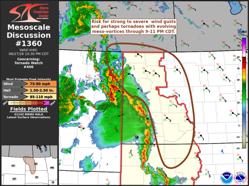
Mesoscale Discussion 1360 NWS Storm Prediction Center Norman OK 0825 PM CDT Sat Jun 27 2026 Areas affected...parts of western into central North Dakota and adjacent portions of South Dakota Concerning...Tornado Watch 406... Valid 280125Z - 280330Z The severe weather threat for Tornado Watch 406 continues. SUMMARY...The risk for strong to severe wind gusts and a few tornadoes appears to be increasing with an organizing cluster of storms, particularly across northwestern into portions of central North Dakota through 9-11 PM CDT. DISCUSSION...Considerable upscale convective growth has occurred the past few hours, focused within the lee surface trough near and east of the Montana/Dakotas state border vicinity. A notable 2-hour surface pressure fall/rise couplet has become evident in 01Z surface observations, along and just ahead of strengthening outflow. Activity is embedded within deep-layer southerly mean flow on the order of 30 kt, with strengthening easterly to northeasterly near-surface inflow of moist air characterized by moderate CAPE likely to support further intensification of convection through 02-03Z. It appears that a meso-beta scale lower/mid-tropospheric cyclonic vortex could form near/south of the Williston vicinity, accompanied by strengthening southwesterly rear-inflow, and increasing potential for severe wind gusts. A few evolving meso-gamma scale vortices may be accompanied by locally more damaging gusts and/or tornadoes. ..Kerr.. 06/28/2026 ...Please see www.spc.noaa.gov for graphic product... ATTN...WFO...ABR...BIS...UNR...GGW... LAT...LON 49250451 48870148 47030057 45570087 45230197 47060274 47500330 47580372 48480472 49250451 MOST PROBABLE PEAK TORNADO INTENSITY...85-110 MPH MOST PROBABLE PEAK WIND GUST...75-90 MPH MOST PROBABLE PEAK HAIL SIZE...1.50-2.50 IN |
|
|
Top/All Mesoscale Discussions/Forecast Products/Home |
|
Source link