| Mesoscale Discussion 1359 | |
| < Previous MD | |

|
|
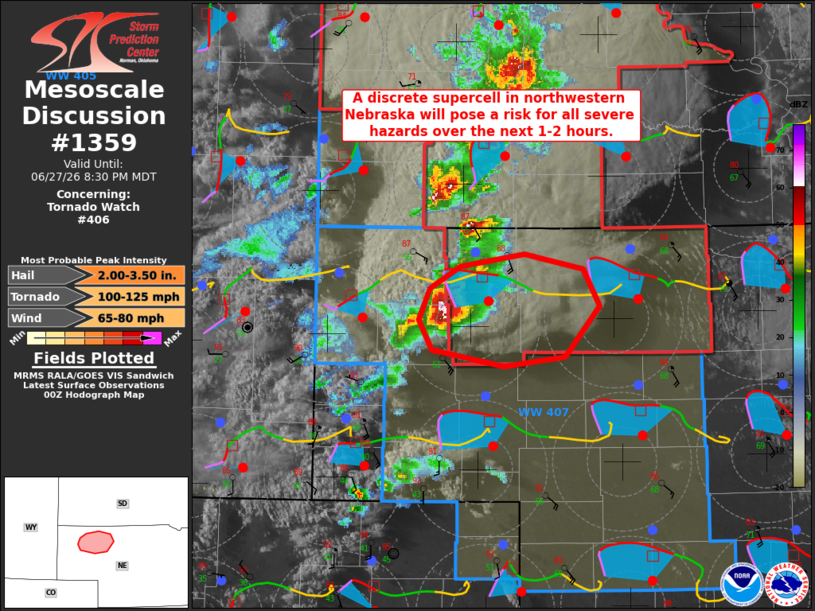
Mesoscale Discussion 1359 NWS Storm Prediction Center Norman OK 0756 PM CDT Sat Jun 27 2026 Areas affected...portions of northwestern Nebraska Concerning...Tornado Watch 406... Valid 280056Z - 280230Z The severe weather threat for Tornado Watch 406 continues. SUMMARY...A discrete supercell in the Nebraska Panhandle will pose a risk for all severe hazards over the next 1-2 hours. DISCUSSION...Regional radar imagery depicts an intensifying, discrete supercell located in Box Butte County, South Dakota. Latest objective analysis places this storm in an environment favorable for all severe hazards, with 4000+ J/kg MLCAPE, SHIP values of 3-4, and effective layer STP of 4-5+ noted within the inflow region. This is supported by strengthening low-level flow and increasingly curved low-level hodographs noted within the LNX VWP, with 40+ kts of southerly flow sampled at 1 km AGL and 0-500 m SRH approaching 200 m2/s2. While modest capping/inhibition remains in this environment, strong dynamical lifting within the mesocyclone should continue to overcome this inhibition for at least another 1-2 hours as it progresses eastward across northwestern Nebraska. ..Chalmers.. 06/28/2026 ...Please see www.spc.noaa.gov for graphic product... ATTN...WFO...LBF...CYS... LAT...LON 42550293 42710262 42800199 42700141 42420126 42060159 41980219 42100291 42320304 42550293 MOST PROBABLE PEAK TORNADO INTENSITY...100-125 MPH MOST PROBABLE PEAK WIND GUST...65-80 MPH MOST PROBABLE PEAK HAIL SIZE...2.00-3.50 IN |
|
|
Top/All Mesoscale Discussions/Forecast Products/Home |
|
Source link