| Mesoscale Discussion 1344 | |
| < Previous MD | |

|
|
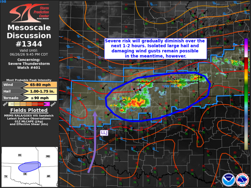
Mesoscale Discussion 1344 NWS Storm Prediction Center Norman OK 0821 PM CDT Fri Jun 26 2026 Areas affected...portions of northern Oklahoma...far southern Kansas...and far southwestern Missouri Concerning...Severe Thunderstorm Watch 401... Valid 270121Z - 270245Z The severe weather threat for Severe Thunderstorm Watch 401 continues. SUMMARY...Widely scattered thunderstorms may persist into the overnight hours, but the severe risk should gradually diminish with time. Isolated large hail and damaging wind gusts remain possible in the short-term, however. DISCUSSION...Ongoing convection has largely congealed into several clusters along developing cold pools and a surface cold front across northern Oklahoma/southern Kansas over the past hour. Modest effective shear (generally 30-35 kts or less) along the southern periphery of a subtle, mid-level wave continues to favor an outflow-dominant, multicellular storm mode and the potential for marginal supercell structures with any discrete convection. While a strengthening low-level jet, with an axis displaced across western Oklahoma, may aid in the maintenance of thunderstorms into tonight, gradual low-level stabilization should yield a diminishing severe risk over the next couple of hours. Isolated large hail and occasional damaging/severe wind gusts will continue to be possible with ongoing convection in the meantime, however. ..Chalmers.. 06/27/2026 ...Please see www.spc.noaa.gov for graphic product... ATTN...WFO...SGF...TSA...ICT...OUN... LAT...LON 36459854 36739823 37139721 37309577 37319474 37189434 36929413 36559423 36499428 36089518 35779626 35669703 35669744 35729779 35899818 36179849 36459854 MOST PROBABLE PEAK TORNADO INTENSITY...UP TO 90 MPH MOST PROBABLE PEAK WIND GUST...65-80 MPH MOST PROBABLE PEAK HAIL SIZE...1.00-1.75 IN |
|
|
Top/All Mesoscale Discussions/Forecast Products/Home |
|
Source link