| Mesoscale Discussion 1342 | |
| < Previous MD | |

|
|
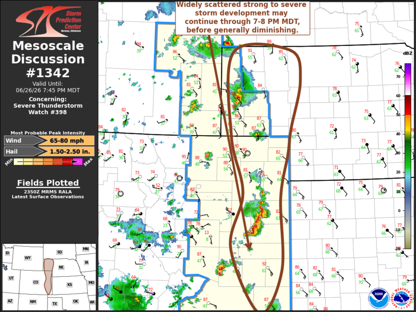
Mesoscale Discussion 1342 NWS Storm Prediction Center Norman OK 0652 PM CDT Fri Jun 26 2026 Areas affected...parts of eastern Colorado...western Nebraska and adjacent portions of the high plains Concerning...Severe Thunderstorm Watch 398... Valid 262352Z - 270145Z The severe weather threat for Severe Thunderstorm Watch 398 continues. SUMMARY...Widely scattered strong storms posing a risk for severe hail and wind will probably continue through 7-8 PM MDT, before tending to diminish across much of the region. DISCUSSION...Isolated to widely scattered strong thunderstorm development continues to propagate into the plains, in the presence of modest, but sheared, 20-25 kt southwesterly deep-layer mean flow. This is where a seasonably moist boundary layer has become characterized by moderate CAPE within a narrow corridor centered near the Kansas/Nebraska state border into western Nebraska. Increasingly warm elevated mixed-layer air continues to advect across the high plains, however, and the onset of boundary-layer cooling will begin to increase inhibition through 00-02Z. Height rises further aloft are forecast to only slowly weaken and shift eastward through late evening. Stronger thunderstorm development currently near Scottsbluff NE seems to have best potential to be maintained beyond the next couple of hours, as low-level wind fields and shear strengthen this evening in closer proximity to the deepening surface cyclone across Wyoming. ..Kerr.. 06/26/2026 ...Please see www.spc.noaa.gov for graphic product... ATTN...WFO...LBF...GLD...PUB...BOU...CYS... LAT...LON 42870370 42900196 42220169 41160198 40590207 39610229 37990228 37040290 38490372 39720339 40990373 42870370 MOST PROBABLE PEAK WIND GUST...65-80 MPH MOST PROBABLE PEAK HAIL SIZE...1.50-2.50 IN |
|
|
Top/All Mesoscale Discussions/Forecast Products/Home |
|
Source link