| Mesoscale Discussion 1341 | |
| < Previous MD | |

|
|
Mesoscale Discussion 1341
NWS Storm Prediction Center Norman OK
0614 PM CDT Fri Jun 26 2026
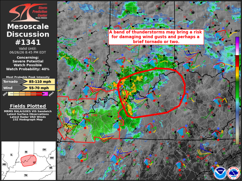
Areas affected...portions of southern Indiana into northern/central
Kentucky
Concerning...Severe potential...Watch possible
Valid 262314Z - 270045Z
Probability of Watch Issuance...40 percent
SUMMARY...A loosely organized band of thunderstorms may bring an
isolated threat for damaging wind gusts and perhaps a brief tornado.
DISCUSSION...A loosely organized band of convection has developed
downstream of a subtle, remnant MCV analyzed north of the lower Ohio
Valley. Latest radar imagery from KLVX depicts a well-defined cold
pool associated with this band. Transient, weak rotation has also
been occasionally noted with this convection. Thus, at least some
potential for isolated damaging wind gusts may accompany this band
for the next 1-2 hours. A modest strengthening of a southwesterly
low-level jet and clockwise low-level hodograph curvature (as
sampled by the LVX VWP) downstream of this band also suggest that a
brief, embedded tornado may be possible. The need for a WW remains
unclear due to uncertainty regarding the persistence/intensity of
this band owing to the loss of diurnal heating and only weak
instability (less than 1000 J/kg MLCAPE per objective analysis).
Trends will continue to be monitored, and a targeted WW may be
considered should a corridor of locally greater severe potential
become evident.
..Chalmers/Mosier.. 06/26/2026
...Please see www.spc.noaa.gov for graphic product...
ATTN...WFO...ILN...LMK...IND...PAH...
LAT...LON 38058708 38358716 38558703 38758640 38918555 38908503
38828475 38668454 38398441 38088444 37708464 37488514
37378602 37328651 37388674 37808699 38058708
MOST PROBABLE PEAK TORNADO INTENSITY...85-110 MPH
MOST PROBABLE PEAK WIND GUST...55-70 MPH
|
|
|
Top/All Mesoscale Discussions/Forecast Products/Home |
|
Source link