| Mesoscale Discussion 1326 | |
| < Previous MD | |

|
|
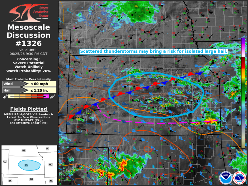
   Mesoscale Discussion 1326
   NWS Storm Prediction Center Norman OK
   0805 PM CDT Thu Jun 25 2026

   Areas affected...portions of central Kansas

   Concerning...Severe potential...Watch unlikely

   Valid 260105Z - 260230Z

   Probability of Watch Issuance...20 percent

   SUMMARY...Scattered thunderstorm development is expected over the
   next several hours. Isolated large hail may occur with the strongest
   storms.

   DISCUSSION...Scattered strong to occasionally severe thunderstorms
   are expected to develop across central Kansas north of a surface
   boundary amid strengthening lower tropospheric warm air advection.
   Effective shear of 40+ kts and MUCAPE of 500-1500 J/kg may support
   some potential for isolated large hail with the most robust cores,
   but a limited thermodynamic environment (mid-level lapse rates
   generally 6.5 C/km or less per latest objective analysis) is
   expected to limit this threat. Given the expectation for the severe
   risk to remain limited in magnitude and coverage, watch issuance
   appears unlikely at this time.

   A conditionally greater severe risk exists to the south of this
   surface boundary across far southern Kansas, but uncertainty remains
   regarding whether thunderstorms will develop/persist farther south.

   ..Chalmers/Mosier.. 06/26/2026

   ...Please see www.spc.noaa.gov for graphic product...

   ATTN...WFO...TOP...ICT...GID...DDC...

   LAT...LON   38909569 39109626 39269690 39389754 39409805 39319901
               39099970 38710004 38450000 38229970 37989927 37789883
               37699827 37679732 37749664 37909593 38189560 38609539
               38779546 38909569

   MOST PROBABLE PEAK WIND GUST...UP TO 60 MPH
   MOST PROBABLE PEAK HAIL SIZE...UP TO 1.25 IN
|
|
|
Top/All Mesoscale Discussions/Forecast Products/Home |
|
Source link