| Mesoscale Discussion 1325 | |
| < Previous MD | |

|
|
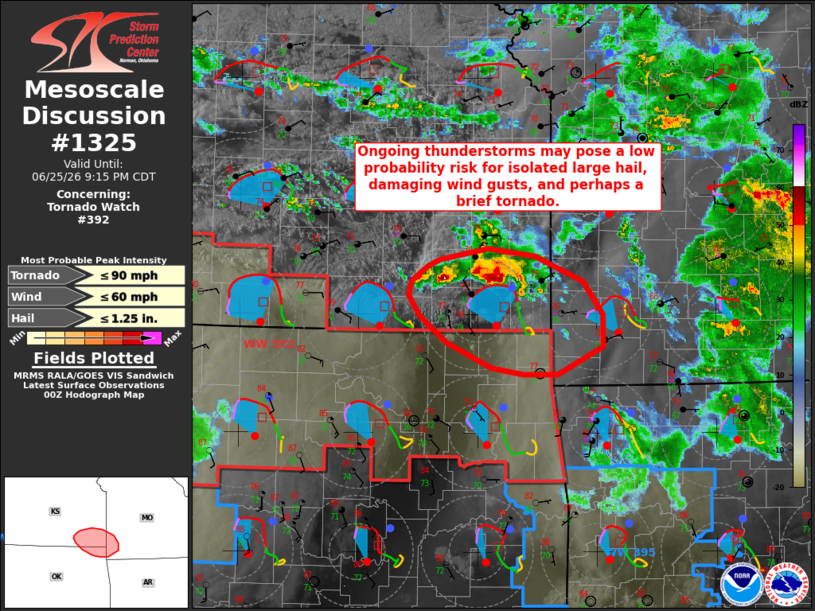
Mesoscale Discussion 1325 NWS Storm Prediction Center Norman OK 0748 PM CDT Thu Jun 25 2026 Areas affected...portions of southeastern Kansas into northeastern Oklahoma and southwestern Missouri Concerning...Tornado Watch 392... Valid 260048Z - 260215Z The severe weather threat for Tornado Watch 392 continues. SUMMARY...Ongoing thunderstorms may pose a low probability risk for large hail, damaging wind gusts, and perhaps a brief tornado. DISCUSSION...A cluster of persistent thunderstorms remain ongoing across portions of southeastern Kansas as of 0040 UTC, with modest intensification noted with one of these cells over the past 30 minutes. While greater low-level inhibition exists to the south in northeastern Oklahoma (owing to outflow from a prior convective cluster), latest objective analysis suggests that a corridor of minimal inhibition exists southeastward from this ongoing cluster into southwestern Missouri. Despite weak mid-level lapse rates (around 6 C/km), strong effective shear of 40+ kts may support a risk for isolated large hail with any stronger storm. A brief tornado also cannot be ruled out given increasingly clockwise-curved, low-level hodographs and effective SRH of 200-300+ m2/s2. The gradual onset of nocturnal low-level cooling/stabilization lends uncertainty to the longevity of this potential risk, however. ..Chalmers.. 06/26/2026 ...Please see www.spc.noaa.gov for graphic product... ATTN...WFO...SGF...TSA...ICT... LAT...LON 36669528 36899580 37139610 37319623 37449619 37579600 37639586 37749532 37669478 37439424 37139402 36859403 36599453 36599492 36669528 MOST PROBABLE PEAK TORNADO INTENSITY...UP TO 90 MPH MOST PROBABLE PEAK WIND GUST...UP TO 60 MPH MOST PROBABLE PEAK HAIL SIZE...UP TO 1.25 IN |
|
|
Top/All Mesoscale Discussions/Forecast Products/Home |
|
Source link