| Mesoscale Discussion 1320 | |
| < Previous MD Next MD > | |

|
|
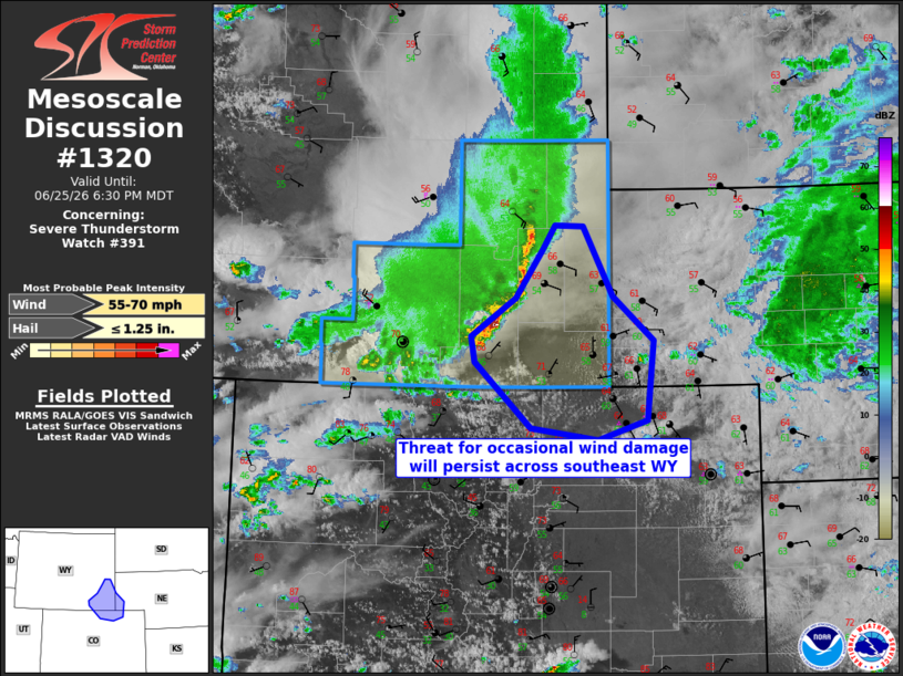
Mesoscale Discussion 1320 NWS Storm Prediction Center Norman OK 0554 PM CDT Thu Jun 25 2026 Areas affected...Southeast Wyoming and adjacent counties of southwest Nebraska and northeast Colorado Concerning...Severe Thunderstorm Watch 391... Valid 252254Z - 260030Z The severe weather threat for Severe Thunderstorm Watch 391 continues. SUMMARY...A convective band with a well formed cold pool will continue developing southeastward with occasional severe gusts into southeast Wyoming and adjacent counties in Nebraska/Colorado. DISCUSSION...Over the past few hours convection has evolved into a well formed leading convective band/trailing stratiform rain configuration, and wind profiles are helping maintain updrafts along the gust front. The storms will likely persist for another 2-3 hours while moving southeastward across southeast WY where slightly warmer temperatures/moisture persist at relatively high elevation, compared to cooler temperatures farther east at lower elevation into the NE Panhandle. Occasional severe outflow gusts of 60-70 mph will be the main threats through 01z. While eastward progress of the stronger storms will be limited by weakening buoyancy with eastward extent into NE, the storms could persist into parts of north/northeast CO with a low-end severe wind threat through about 03z. Since the potential area affected outside of the existing watch in WY) is small, the need for a downstream watch is not clear. ..Thompson.. 06/25/2026 ...Please see www.spc.noaa.gov for graphic product... ATTN...WFO...BOU...CYS... LAT...LON 41910399 41470344 40650353 40450420 40570509 41240585 41510590 41900531 42390494 42630477 42630440 41910399 MOST PROBABLE PEAK WIND GUST...55-70 MPH MOST PROBABLE PEAK HAIL SIZE...UP TO 1.25 IN |
|
|
Top/All Mesoscale Discussions/Forecast Products/Home |
|
Source link