| Mesoscale Discussion 1302 | |
| < Previous MD | |

|
|
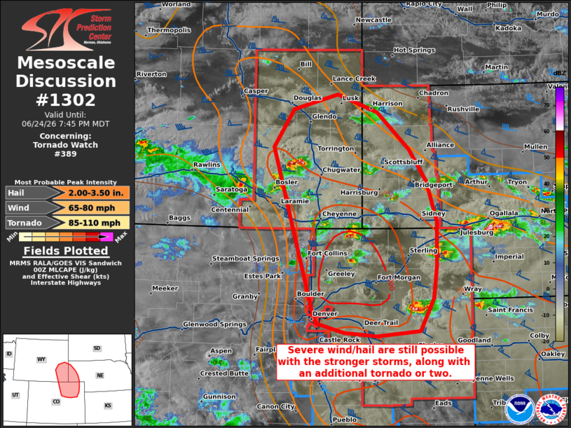
Mesoscale Discussion 1302 NWS Storm Prediction Center Norman OK 0747 PM CDT Wed Jun 24 2026 Areas affected...portions of southeastern Wyoming into northeastern Colorado and western Nebraska Panhandle Concerning...Tornado Watch 389... Valid 250047Z - 250145Z The severe weather threat for Tornado Watch 389 continues. SUMMARY...Severe hail and wind remain a concern with the more robust storms across portions of the central High Plains. An isolated tornado risk will also continue for at least a few more hours. DISCUSSION...Multiple supercells have oscillated in intensity across portions of southeastern WY into northeastern CO and western NE Panhandle, some of which have produced severe hail/gusts. Furthermore, at least one brief tornado reported in northeastern CO over the past hour. These storms are benefiting from a favorable kinematic and thermodynamic ambient environment, characterized by 2500-3500 J/kg MLCAPE and up to 60 kts of effective bulk shear per 00Z mesoanalysis. Storms closest to an effective baroclinic boundary also have the advantage of ingesting locally higher effective SRH, ranging from 200-500 m2/s2. The current thinking is that storms will continue to pulse in intensity through the remainder of daylight hours, producing severe wind and hail at their peak moments of intensity/organization. Additionally, isolated tornadoes will remain possible with mature supercells within the baroclinic zone. ..Squitieri.. 06/25/2026 ...Please see www.spc.noaa.gov for graphic product... ATTN...WFO...GLD...BOU...CYS... LAT...LON 39560298 39490377 39530438 39670489 39770494 42140570 42670532 42870450 42620376 42100318 41660285 41090266 40470268 40010274 39560298 MOST PROBABLE PEAK TORNADO INTENSITY...85-110 MPH MOST PROBABLE PEAK WIND GUST...65-80 MPH MOST PROBABLE PEAK HAIL SIZE...2.00-3.50 IN |
|
|
Top/All Mesoscale Discussions/Forecast Products/Home |
|
Source link