| Mesoscale Discussion 1289 | |
| < Previous MD | |

|
|
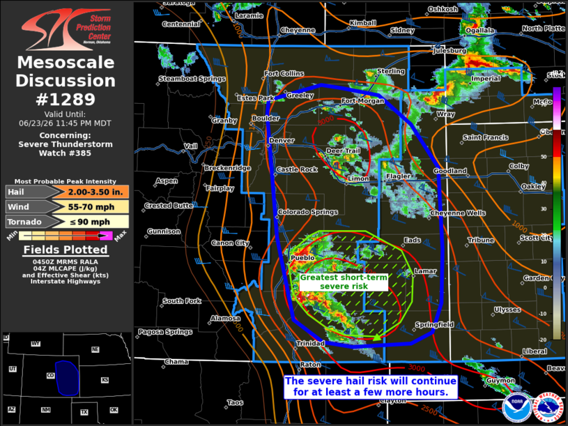
Mesoscale Discussion 1289 NWS Storm Prediction Center Norman OK 1152 PM CDT Tue Jun 23 2026 Areas affected...portions of eastern Colorado Concerning...Severe Thunderstorm Watch 385... Valid 240452Z - 240545Z The severe weather threat for Severe Thunderstorm Watch 385 continues. SUMMARY...The severe hail risk continues with ongoing supercells, and this risk should persist for at least a few more hours. DISCUSSION...Multiple supercells continue to progress across central and eastern CO, with the strongest storms (and associated greatest risk for severe hail) ongoing from El Paso to Las Animas Counties. Up to 3500 J/kg MLCAPE and 60 kts of effective bulk shear precedes these storms, and strong buoyancy should linger through the early morning hours given upper 60s F surface dewpoints in place. As such, the severe hail risk (including a few stones exceeding 2 inches in diameter) will continue for several more hours, and a few severe gusts may occur as well. The risk for severe gusts may also increase if the larger storms in southern CO can merge into an MCS. ..Squitieri.. 06/24/2026 ...Please see www.spc.noaa.gov for graphic product... ATTN...WFO...GLD...PUB...BOU... LAT...LON 37530452 38570481 40120499 40300497 40510411 40470375 40370316 40000262 39450218 38410213 37730217 37370232 37220266 37180358 37250405 37530452 MOST PROBABLE PEAK TORNADO INTENSITY...UP TO 90 MPH MOST PROBABLE PEAK WIND GUST...55-70 MPH MOST PROBABLE PEAK HAIL SIZE...2.00-3.50 IN |
|
|
Top/All Mesoscale Discussions/Forecast Products/Home |
|
Source link