| Mesoscale Discussion 1275 | |
| < Previous MD | |

|
|
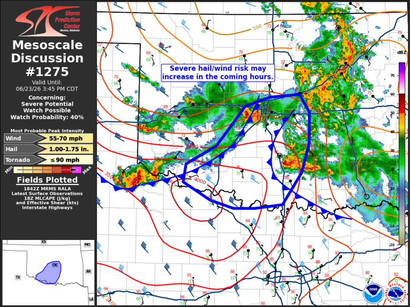
Mesoscale Discussion 1275 NWS Storm Prediction Center Norman OK 0144 PM CDT Tue Jun 23 2026 Areas affected...Central to southern Oklahoma Concerning...Severe potential...Watch possible Valid 231844Z - 232045Z Probability of Watch Issuance...40 percent SUMMARY...An uptick in thunderstorm coverage is expected over the next 1-2 hours as outflow boundaries begin to collide. Storms may be capable of large hail and severe gusts. Watch issuance may be needed. DISCUSSION...Two outflow boundaries are apparent in surface observations and radar imagery across central OK. Recent development along the northern outflow boundary near/west of the OKC metro has produce a strong wind signature with observed gusts between 50-60 mph per Mesonet observations. Additionally, MRMS VII trends show periodic severe hail signals. Given a nose of 1500-2500 J/kg MLCAPE in place ahead of both outflow boundaries, additional thunderstorm development appears likely in the next couple of hours. 30-35 knot 0-6 km BWD values observed at KILX ahead of the boundaries suggests storms may see transient organization with an attendant hail/wind threat prior to destructive interference from neighboring cells and/or cold outflow. The expected transient nature of the convection (similar to what is being observed across southern OK) casts uncertainty on whether the severe threat will be sufficiently prolonged and/or widespread to warrant additional watch issuance and/or expansion of WW 380. ..Moore/Guyer.. 06/23/2026 ...Please see www.spc.noaa.gov for graphic product... ATTN...WFO...FWD...OUN... LAT...LON 34569904 34879846 35219814 35509790 35669739 35709682 35409663 34919664 34449679 33929717 33859771 33859812 33989856 34279910 34569904 MOST PROBABLE PEAK TORNADO INTENSITY...UP TO 90 MPH MOST PROBABLE PEAK WIND GUST...55-70 MPH MOST PROBABLE PEAK HAIL SIZE...1.00-1.75 IN |
|
|
Top/All Mesoscale Discussions/Forecast Products/Home |
|
Source link