| Mesoscale Discussion 1260 | |
| < Previous MD | |

|
|
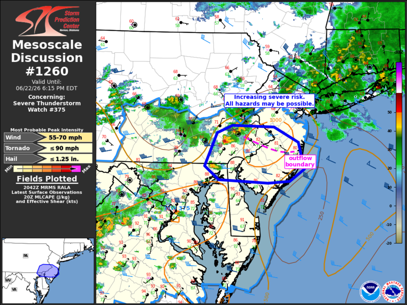
Mesoscale Discussion 1260 NWS Storm Prediction Center Norman OK 0345 PM CDT Mon Jun 22 2026 Areas affected...southeast PA into NJ Concerning...Severe Thunderstorm Watch 375... Valid 222045Z - 222215Z The severe weather threat for Severe Thunderstorm Watch 375 continues. SUMMARY...Supercell thunderstorm risk increasing. Damaging winds, hail, and possibly a tornado could accompany this activity across far southeast Pennsylvania into southern New Jersey over the next 1-2 hours. DISCUSSION...A supercell storm has developed across southeast PA this afternoon within a favorably sheared and unstable environment. Surface observations indicate potential outflow oriented west to east across the area from earlier storms. While the downstream airmass itself will support a severe risk, if this supercell can maintain organization and interact with this outflow boundary (where 0-1 km SRH would be enhanced), an increasing risk for a tornado also could occur in addition to damaging wind and isolated hail. An additional storm approaching northern DE also will be moving into a more favorable airmass supporting strong to damaging wind gusts over the next hour. ..Leitman.. 06/22/2026 ...Please see www.spc.noaa.gov for graphic product... ATTN...WFO...PHI...CTP...LWX... LAT...LON 40387566 40357472 40097417 39627405 39407438 39387486 39437597 39687630 40257601 40387566 MOST PROBABLE PEAK TORNADO INTENSITY...UP TO 90 MPH MOST PROBABLE PEAK WIND GUST...55-70 MPH MOST PROBABLE PEAK HAIL SIZE...UP TO 1.25 IN |
|
|
Top/All Mesoscale Discussions/Forecast Products/Home |
|
Source link