| Mesoscale Discussion 1259 | |
| < Previous MD Next MD > | |

|
|
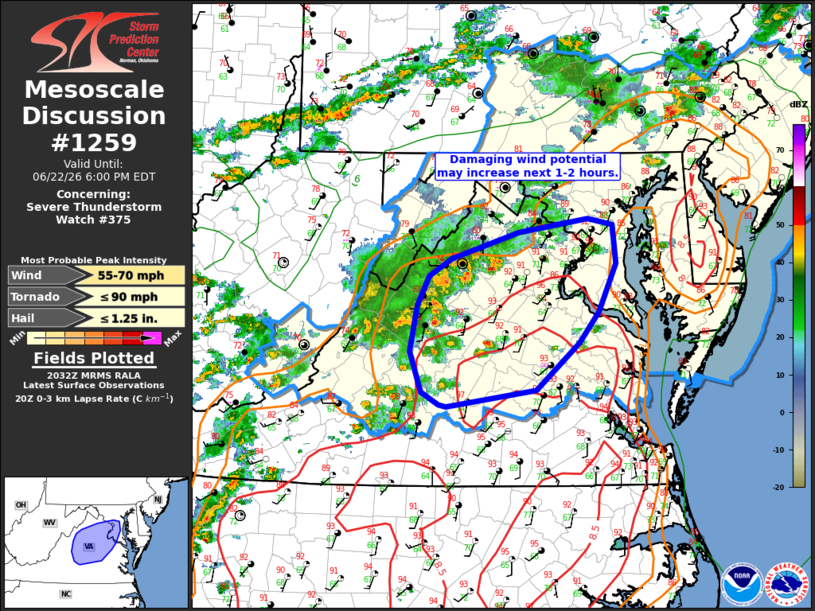
Mesoscale Discussion 1259 NWS Storm Prediction Center Norman OK 0334 PM CDT Mon Jun 22 2026 Areas affected...portions of northern/central VA Concerning...Severe Thunderstorm Watch 375... Valid 222034Z - 222200Z The severe weather threat for Severe Thunderstorm Watch 375 continues. SUMMARY...Thunderstorm clusters may pose an increasing risk for damaging winds across portions of northern and central Virginia over the next 1-2 hours. DISCUSSION...Thunderstorm clusters moving over the Blue Ridge Mountains and into northern/central VA may pose an increasing risk for damaging wind gusts the next 1-2 hours. These storms will continue tracking east/northeast into a hot airmass with steep 0-3 km lapse rates around 7.5-8.5 C/km. Sufficient instability (1000-1500 J/kg MLCAPE) and 30 kt effective shear magnitudes should support at least transient storm organization and some increase in intensity in the short term. ..Leitman.. 06/22/2026 ...Please see www.spc.noaa.gov for graphic product... ATTN...WFO...AKQ...LWX...RNK... LAT...LON 38717862 38977780 39107696 39037667 38677663 38217684 37907707 37467759 37297868 37327878 37437899 37837913 38267904 38547890 38717862 MOST PROBABLE PEAK TORNADO INTENSITY...UP TO 90 MPH MOST PROBABLE PEAK WIND GUST...55-70 MPH MOST PROBABLE PEAK HAIL SIZE...UP TO 1.25 IN |
|
|
Top/All Mesoscale Discussions/Forecast Products/Home |
|
Source link