| Mesoscale Discussion 1231 | |
| < Previous MD | |

|
|
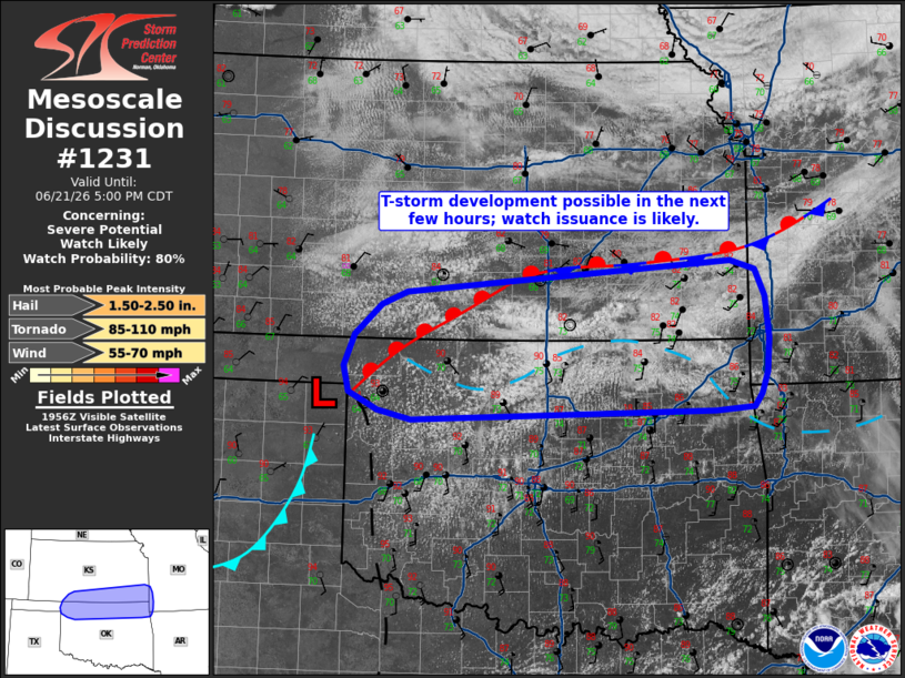
   Mesoscale Discussion 1231
   NWS Storm Prediction Center Norman OK
   0301 PM CDT Sun Jun 21 2026

   Areas affected...Northern Oklahoma...southern Kansas...and adjacent
   portions of southwest Missouri and northwest Arkansas

   Concerning...Severe potential...Watch likely

   Valid 212001Z - 212200Z

   Probability of Watch Issuance...80 percent

   SUMMARY...Conditions are being monitored for thunderstorm
   development across northern Oklahoma, southern Kansas. While exact
   timing remains uncertain, watch issuance is likely by early evening
   once thunderstorms begin to mature within a favorable environment.

   DISCUSSION...Latest surface observations and GOES imagery shows the
   northward advancement of an outflow boundary across northern OK to
   the east of a surface low in place across the far northeast TX
   Panhandle. A recent 18 UTC RAOB from DDC and the presence of a
   gravity wave along the OK/KS border suggests that pockets of
   inhibition remain in place along/north of the boundary. However,
   GOES daytime RGB imagery shows a few patches of glaciating cumulus
   along and just north of the boundary to the southeast of the
   Wichita, KS area - likely due to isentropic ascent over the
   boundary. Continued heating through late afternoon will act to
   reduce any lingering inhibition and should promote increasing
   probabilities for surface-based thunderstorm development, especially
   given the very warm/moist air mass in place along and south of the
   boundary (MLCAPE recently analyzed near 3000 J/kg).

   Recent forecast soundings (validated by recent KINX VWP
   observations) depict a nearly zonal wind profile above 3 km with
   effective bulk shear values on the order of 45-55 knots. This wind
   profile will promote initial thunderstorm organization into
   supercells capable of producing large to very large hail. Weak
   low-level veering noted in regional VWPs may support some risk for a
   brief tornado, but generally weak flow through the boundary layer
   should modulate the overall tornado threat. Watch issuance will
   likely be needed, but timing and placement will be conditional on
   when and where intense thunderstorm development becomes more
   probable along the OK/KS border.

   ..Moore/Hart.. 06/21/2026

   ...Please see www.spc.noaa.gov for graphic product...

   ATTN...WFO...SGF...TSA...ICT...OUN...DDC...AMA...

   LAT...LON   36419999 36700006 37039991 37379956 37509922 37859486
               37759452 37469439 37009435 36639437 36409446 36269456
               36239508 36139914 36239960 36419999

   MOST PROBABLE PEAK TORNADO INTENSITY...85-110 MPH
   MOST PROBABLE PEAK WIND GUST...55-70 MPH
   MOST PROBABLE PEAK HAIL SIZE...1.50-2.50 IN
|
|
|
Top/All Mesoscale Discussions/Forecast Products/Home |
|
Source link