| Mesoscale Discussion 1226 | |
| < Previous MD | |

|
|
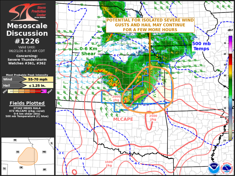
Mesoscale Discussion 1226 NWS Storm Prediction Center Norman OK 0236 AM CDT Sun Jun 21 2026 Areas affected...Southeast Kansas...Far Northern Oklahoma...Far Western Missouri Concerning...Severe Thunderstorm Watch 361...362... Valid 210736Z - 210930Z The severe weather threat for Severe Thunderstorm Watch 361, 362 continues. SUMMARY...An isolated threat severe wind gusts and hail may continue across parts of southern and eastern Kansas early this morning. The threat may also impact far northern Oklahoma and far western Missouri. DISCUSSION...An MCS is ongoing across much of Kansas, along the northern edge of a moist and unstable airmass. Moderate instability is analyzed ahead of and to the south of the MCS with the RAP showing MLCAPE from 1000 J/kg in eastern Kansas to 2500 J/kg in north-central Oklahoma. The instability, along with large-scale ascent associated with a mid-level shortwave trough over the central Plains, will continue to support the MCS for much of the morning. Regional WSR-88D VWPs in northeast Oklahoma and south-central Kansas have 0-6 km shear in the 35 to 40 knot range suggesting that the stronger embedded cells could be supercellular and have some severe potential. Hail will be possible with supercells. Severe wind gusts will likely be concentrated along short bowing line segments. Recently, the MCS has become less organized. This trend could continue as inhibition increases, resulting in a more isolated and marginal severe threat with time. ..Broyles.. 06/21/2026 ...Please see www.spc.noaa.gov for graphic product... ATTN...WFO...SGF...EAX...TSA...TOP...ICT...OUN... LAT...LON 39289573 39109454 38519403 37659395 37139408 36749453 36469523 36449661 36669755 36939787 37269794 37689779 38319714 39099637 39289573 MOST PROBABLE PEAK WIND GUST...55-70 MPH MOST PROBABLE PEAK HAIL SIZE...UP TO 1.25 IN |
|
|
Top/All Mesoscale Discussions/Forecast Products/Home |
|
Source link