| Mesoscale Discussion 1191 | |
| < Previous MD | |

|
|
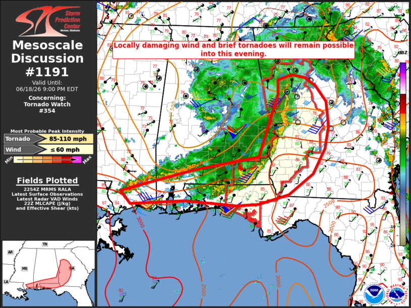
Mesoscale Discussion 1191 NWS Storm Prediction Center Norman OK 0555 PM CDT Thu Jun 18 2026 Areas affected...the central Gulf Coast into parts of GA Concerning...Tornado Watch 354... Valid 182255Z - 190100Z The severe weather threat for Tornado Watch 354 continues. SUMMARY...Locally damaging wind and brief tornadoes will remain possible into this evening. DISCUSSION...An extensive QLCS is ongoing as of 2255 UTC from western GA into southern AL. Rather strong low/midlevel flow remains in place along/ahead of this QLCS, in association with a midlevel shortwave trough and the remnants of TC Arthur. 0-1 km SRH of 150-250 m2/s2 within the moist/tropical environment will continue to support brief-tornado potential, especially where the line has taken a more north-south orientation across western GA. There is some evidence of a moderately strong westerly rear-inflow jet from the KEOX VWP, which will support damaging-wind potential along that portion of the QLCS as it moves eastward across southwest GA and southeast AL. Substantial convection persists farther southwest into southern MS and southwest AL. Some enhancement to low-level shear/SRH persists in this area, which could support a wind-damage and brief-tornado threat in this region as well. However, the QLCS has taken on a less favorable east-west orientation in this area, which may tend to limit a more organized severe threat. Trends will continue to be monitored in this area for an uptick in storm intensity and organization this evening. ..Dean.. 06/18/2026 ...Please see www.spc.noaa.gov for graphic product... ATTN...WFO...FFC...TAE...BMX...MOB...LIX... LAT...LON 30778947 31368731 31698541 33298483 33648484 33788442 33698401 33488369 33088340 32458334 31888346 31268382 30738454 30508541 30458607 30578759 30458917 30778947 MOST PROBABLE PEAK TORNADO INTENSITY...85-110 MPH MOST PROBABLE PEAK WIND GUST...UP TO 60 MPH |
|
|
Top/All Mesoscale Discussions/Forecast Products/Home |
|
Source link