| Mesoscale Discussion 1178 | |
| < Previous MD | |

|
|
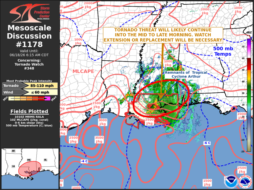
Mesoscale Discussion 1178 NWS Storm Prediction Center Norman OK 0512 AM CDT Thu Jun 18 2026 Areas affected...Eastern Louisiana...Southern Mississippi...Southwest Alabama Concerning...Tornado Watch 348... Valid 181012Z - 181115Z The severe weather threat for Tornado Watch 348 continues. SUMMARY...A tornado threat will likely continue into the mid to late morning over parts of eastern Louisiana and southern Mississippi. The threat may also impact southwest Alabama. A watch extension or replacement watch will be needed. DISCUSSION...The remnants of Tropical Cyclone Arthur is currently moving inland across the lower Mississippi Valley. On the southwestern edge of the system, multiple supercells are ongoing that are capable of producing tornadoes. These storms are located just to west and north of New Orleans, near the center of a 40 knot low-level speed max analyzed by the RAP. In this vicinity, the latest WSR-88D VWP to the northwest of Lake Pontchartrain currently shows a looped hodograph, with 30 to 40 knots of flow in the lowest 2 km above ground level. This environment will support a continued tornado threat as the system moves slowly north-northeastward this morning. Isolated severe wind gusts will also be possible. ..Broyles.. 06/18/2026 ...Please see www.spc.noaa.gov for graphic product... ATTN...WFO...MOB...JAN...LIX...LCH... LAT...LON 31169115 31609043 31808961 31858873 31718811 31418771 31018760 30618771 30358798 29978858 29588976 29569045 29649104 30019154 30669156 31169115 MOST PROBABLE PEAK TORNADO INTENSITY...85-110 MPH MOST PROBABLE PEAK WIND GUST...UP TO 60 MPH |
|
|
Top/All Mesoscale Discussions/Forecast Products/Home |
|
Source link