| Mesoscale Discussion 1176 | |
| < Previous MD | |

|
|
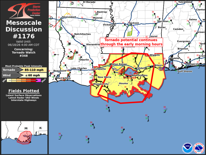
Mesoscale Discussion 1176 NWS Storm Prediction Center Norman OK 0204 AM CDT Thu Jun 18 2026 Areas affected...Southern portions of Louisiana and Mississippi Concerning...Tornado Watch 348... Valid 180704Z - 180900Z The severe weather threat for Tornado Watch 348 continues. SUMMARY...The potential for tornadoes will continue to focus primarily across southeast Louisiana near/to the south of I-12/I-10 over the next several hours (predawn). DISCUSSION...Related to Post-Tropical Cyclone Arthur, regional WSR-88D data indicate a continued strengthening of south-southwesterly winds (30-40 kt) in the lowest 1-2 km AGL across southern portions of Louisiana and Mississippi. This same trend is expected to continue through the early morning hours with a further strengthening and gradual east-northeastward expansion of the stronger low-level wind field. The most buoyant low-level air mass will tend to stay relegated to within 50-75 miles of the southern Louisiana coast over the next several hours, with this being the primary area for tornado potential in the predawn hours. ..Guyer.. 06/18/2026 ...Please see www.spc.noaa.gov for graphic product... ATTN...WFO...MOB...JAN...LIX...LCH... LAT...LON 29179176 30659097 31029005 30978921 30518887 29368910 28858949 28789061 29179176 MOST PROBABLE PEAK TORNADO INTENSITY...85-110 MPH MOST PROBABLE PEAK WIND GUST...UP TO 60 MPH |
|
|
Top/All Mesoscale Discussions/Forecast Products/Home |
|
Source link