| Mesoscale Discussion 1153 | |
| < Previous MD | |

|
|
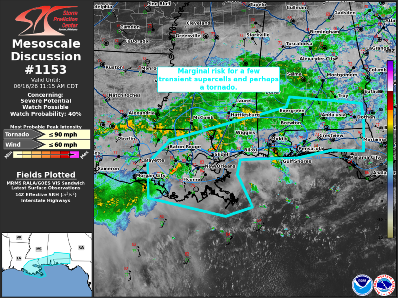
   Mesoscale Discussion 1153
   NWS Storm Prediction Center Norman OK
   0916 AM CDT Tue Jun 16 2026

   Areas affected...southeastern Louisiana...southern
   Mississippi...southern Alabama...Florida Panhandle

   Concerning...Severe potential...Watch possible

   Valid 161416Z - 161615Z

   Probability of Watch Issuance...40 percent

   SUMMARY...Marginal risk for a few transient supercell structures
   through the morning/afternoon.

   DISCUSSION...Within the broader widespread thunderstorm activity
   across the Gulf states, a few cells have exhibited transient
   supercell characteristics in the last hour. Across this region,
   tropical moisture is streaming northward from a disturbance across
   far southern Texas. Strengthening 700-850 mb flow across the Gulf
   coast amid this tropical air mass will support occasional stronger
   cells with transient supercell characteristics. These will have the
   potential to produce isolated damaging winds and perhaps a tornado.
   Due to the limited coverage and transient nature of this potential,
   a watch is unlikely to be needed but this area will be monitored for
   changes through the afternoon.

   ..Thornton/Hart.. 06/16/2026

   ...Please see www.spc.noaa.gov for graphic product...

   ATTN...WFO...TAE...BMX...MOB...JAN...LIX...LCH...

   LAT...LON   30729111 30079177 29169172 28728940 28968859 29418881
               29838905 30218895 30278720 30458617 30398519 31088515
               31668520 31888744 31628753 30729111

   MOST PROBABLE PEAK TORNADO INTENSITY...UP TO 90 MPH
   MOST PROBABLE PEAK WIND GUST...UP TO 60 MPH
|
|
|
Top/All Mesoscale Discussions/Forecast Products/Home |
|
Source link