| Mesoscale Discussion 1120 | |
| < Previous MD | |

|
|
Mesoscale Discussion 1120
NWS Storm Prediction Center Norman OK
1200 PM CDT Sat Jun 13 2026
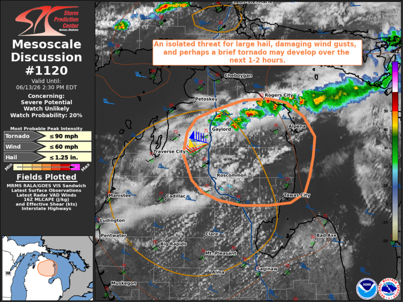
Areas affected...portions of northern Lower Michigan
Concerning...Severe potential...Watch unlikely
Valid 131700Z - 131830Z
Probability of Watch Issuance...20 percent
SUMMARY...An isolated threat for large hail, damaging wind gusts,
and perhaps a brief tornado may develop over the next 1-2 hours
across portions of northern Lower Michigan.
DISCUSSION...A broken band of thunderstorms has developed along a
weak confluence zone immediately downstream of a subtle, mid-level
shortwave trough evident over northern Lake Michigan in latest GOES
water vapor imagery. Northward moist advection ahead/south of this
band has resulted in surface dewpoints increasing to near 60 F, with
temperatures warming into the mid-70s. Modifying the 12z APX
observed sounding for these conditions suggests that weak buoyancy
has developed as of early afternoon, with around 500 J/kg MLCAPE
(locally up to 1000 J/kg per latest objective analysis). While
further destabilization is not expected to be substantial, strong
mid-level flow (50-60 kts sampled by the APX VWP at 2-3 km AGL) and
effective shear of 50-60 kts will support updraft organization as
ongoing convection evolves east-southeastward across northern Lower
Michigan over the next 1-2 hours.
Despite generally weak instability, the strong effective shear,
modestly steep mid-level lapse rates (around 7 C/km per latest
mesoanalysis), and steepening low-level lapse rates will promote
some potential for isolated large hail and damaging wind gusts with
any convection that can become better organized. A brief tornado
also cannot be ruled out given 0-1 km SRH of 100-150 m2/s2 sampled
by the APX VWP and indicated by latest objective analysis. Watch
issuance appears unlikely at this time owing to the expectation for
the severe risk to remain isolated and limited in magnitude.
..Chalmers/Mosier.. 06/13/2026
...Please see www.spc.noaa.gov for graphic product...
ATTN...WFO...APX...
LAT...LON 44978298 44748301 44518307 44338316 44228338 44188375
44198416 44258455 44338480 44478497 44788511 45028505
45198491 45278464 45408414 45428373 45368344 45208317
44978298
MOST PROBABLE PEAK TORNADO INTENSITY...UP TO 90 MPH
MOST PROBABLE PEAK WIND GUST...UP TO 60 MPH
MOST PROBABLE PEAK HAIL SIZE...UP TO 1.25 IN
|
|
|
Top/All Mesoscale Discussions/Forecast Products/Home |
|
Source link