| Mesoscale Discussion 1112 | |
| < Previous MD | |

|
|
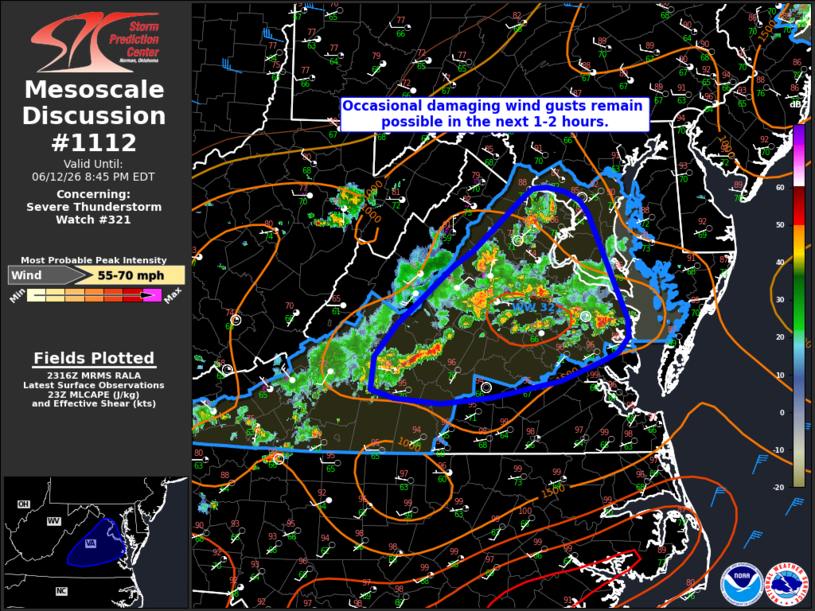
Mesoscale Discussion 1112 NWS Storm Prediction Center Norman OK 0619 PM CDT Fri Jun 12 2026 Areas affected...portions of the Mid-Atlantic...including Washington D.C. Concerning...Severe Thunderstorm Watch 321... Valid 122319Z - 130045Z The severe weather threat for Severe Thunderstorm Watch 321 continues. SUMMARY...A gradual decrease in convective intensity and coverage is expected through the next 1-2 hours. Some potential for occasional damaging wind gusts will continue in the meantime. DISCUSSION...Regional radar imagery continues to depicts scattered thunderstorms across Severe Thunderstorm Watch 321, with a downburst recently producing a measured 58 kt (67 mph) wind gust at Dulles airport. Downstream surface observations across southeastern Virginia indicate surface temperatures are beginning to cool, with a dissipation of boundary layer cumulus also noted on visible satellite. As nocturnal cooling/stabilization continues, a gradual decrease in convective coverage and intensity is expected over the next 1-2 hours. Some potential for occasional damaging wind gusts will persist in the near-term, however, with the greatest potential likely to accompany any stronger downbursts. A local watch extension may be needed, particularly in southeastern Virginia, should a stronger storm or two persist after 01z, but a new Severe Thunderstorm Watch is not anticipated. ..Chalmers.. 06/12/2026 ...Please see www.spc.noaa.gov for graphic product... ATTN...WFO...AKQ...LWX...RNK... LAT...LON 39097751 39107734 39057713 38977694 38847685 38057647 37827637 37657636 37507649 37437665 37247718 37077803 37017864 37077920 37147947 37467943 37777916 38337849 38507824 38987766 39097751 MOST PROBABLE PEAK WIND GUST...55-70 MPH |
|
|
Top/All Mesoscale Discussions/Forecast Products/Home |
|
Source link