| Mesoscale Discussion 1110 | |
| < Previous MD | |

|
|
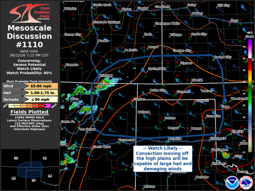
   Mesoscale Discussion 1110
   NWS Storm Prediction Center Norman OK
   0510 PM CDT Fri Jun 12 2026

   Areas affected...South-Central High Plains into the Oklahoma and
   Texas Panhandles

   Concerning...Severe potential...Watch likely

   Valid 122210Z - 130015Z

   Probability of Watch Issuance...80 percent

   SUMMARY...A severe thunderstorm watch is likely be issued soon in
   anticipation of upscale convective growth with storms currently
   moving off the higher terrain and into the south-central plains.
   Hail and damaging straight line winds up to 80 MPH will be the
   primary threat.

   DISCUSSION...A small cluster of thunderstorms in northeastern New
   Mexico is expected to move eastward off the higher terrain and into
   the high plains over the next few hours, where buoyancy and shear
   increase with longitudinal extent. Short term forecast guidance and
   current mesoanalysis trends suggests this cluster of convection will
   grow upscale into a linear convective system with one or more
   embedded bowing line segments. Steep lapse rates from strong diurnal
   heating, rich moisture content in the boundary layer, and an
   intensifying nocturnal low-level jet will support primarily a
   damaging wind threat, particularly along the leading edge of
   convection and with any bowing line segments. A severe thunderstorm
   watch is likely to be issued soon.

   ..Halbert/Gleason.. 06/12/2026

   ...Please see www.spc.noaa.gov for graphic product...

   ATTN...WFO...OUN...DDC...AMA...PUB...ABQ...

   LAT...LON   37340444 37700374 37860247 37870152 37870053 37870012
               37759988 37449970 36599963 36259971 35879971 35469986
               35400017 35350129 35290267 35350361 35380428 35570461
               35960472 36370477 36820479 36960475 37340444

   MOST PROBABLE PEAK TORNADO INTENSITY...UP TO 90 MPH
   MOST PROBABLE PEAK WIND GUST...65-80 MPH
   MOST PROBABLE PEAK HAIL SIZE...1.00-1.75 IN
|
|
|
Top/All Mesoscale Discussions/Forecast Products/Home |
|
Source link