| Mesoscale Discussion 1097 | |
| < Previous MD | |

|
|
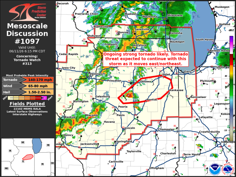
Mesoscale Discussion 1097 NWS Storm Prediction Center Norman OK 0513 PM CDT Thu Jun 11 2026 Areas affected...portions of central into northeast Illinois Concerning...Tornado Watch 313... Valid 112213Z - 112315Z The severe weather threat for Tornado Watch 313 continues. SUMMARY...A strong tornado is likely ongoing across Woodford County, Illinois. The strong tornado threat from this storm is expected to continue for several more hours as it moves northeast. DISCUSSION...A debris ball has developed within a low-reflectivity hook west of Washburn, Illinois at 2205Z. This supercell is in a very favorable environment near the modifying outflow boundary across north-central Illinois. The KILX 21Z RAOB showed a very favorable environment with 0-500m SRH of 151 m2/s2. Recent VWP trends from ILX suggest this las likely increased within the past hour also. Given the continued northward movement of the outflow boundary and the discrete nature of this storm, expect an EF3+ tornado threat to continue for several more hours this evening as it moves east/northeast. ..Bentley/Smith.. 06/11/2026 ...Please see www.spc.noaa.gov for graphic product... ATTN...WFO...LOT...ILX...DVN... LAT...LON 40968956 41468879 41548810 41438778 41228773 40968813 40858889 40828939 40968956 MOST PROBABLE PEAK TORNADO INTENSITY...140-170 MPH MOST PROBABLE PEAK WIND GUST...65-80 MPH MOST PROBABLE PEAK HAIL SIZE...1.50-2.50 IN |
|
|
Top/All Mesoscale Discussions/Forecast Products/Home |
|
Source link