| Mesoscale Discussion 1088 | |
| < Previous MD Next MD > | |

|
|
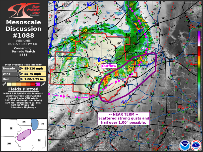
Mesoscale Discussion 1088 NWS Storm Prediction Center Norman OK 1222 PM CDT Thu Jun 11 2026 Areas affected...parts of north/central Illinois Concerning...Tornado Watch 311... Valid 111722Z - 111845Z The severe weather threat for Tornado Watch 311 continues. SUMMARY...Storms may produce hail over 1.00" and locally damaging gusts through midday. Tornado risk is still expected to increase later this afternoon ahead of the upper trough. DISCUSSION...Scattered strong to severe storms persist just north of an outflow boundary associated with the MCS which moved across IA this morning. As expected, the more stable air mass residing ahead of the MCS has resulted in weakening. At this time, radar and surface obs continue to show the outflow proceeding east/southeast across northern IL, with primarily elevated storms with periodic strong cores traveling east/northeast. These storms may continue to pose a hail or locally damaging gust threat. Notably, GPS PWAT sensors continue to show increasing values (1.60-1.85") out of MO and into IL, as surface temperatures continue to rise. The cold front and shortwave trough are well to the west, and southwest low-level winds will persist over the warm sector. It is expected that the outflow boundary with the MCS will stall and mix/retreat later this afternoon. Shear profiles will become increasingly favorable for supercells and tornadoes at that time, with additional watches likely. ..Jewell.. 06/11/2026 ...Please see www.spc.noaa.gov for graphic product... ATTN...WFO...LOT...ILX...LSX...DVN... LAT...LON 40188959 39919041 39989082 40249104 40579098 40919074 41089042 41328981 41698920 41878814 41778800 41148807 40518902 40188959 MOST PROBABLE PEAK TORNADO INTENSITY...85-110 MPH MOST PROBABLE PEAK WIND GUST...55-70 MPH MOST PROBABLE PEAK HAIL SIZE...1.00-1.75 IN |
|
|
Top/All Mesoscale Discussions/Forecast Products/Home |
|
Source link