| Mesoscale Discussion 1084 | |
| < Previous MD | |

|
|
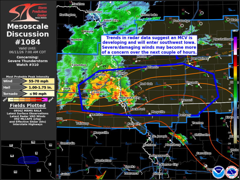
Mesoscale Discussion 1084 NWS Storm Prediction Center Norman OK 0459 AM CDT Thu Jun 11 2026 Areas affected...Southeast Nebraska into south-central Iowa Concerning...Severe Thunderstorm Watch 310... Valid 110959Z - 111200Z The severe weather threat for Severe Thunderstorm Watch 310 continues. SUMMARY...With an organizing MCV moving into southwest Iowa, the threat for strong/severe surface gusts is expected to increase. DISCUSSION...Velocity data from KOAX suggest that an MCV has recently developed centered east of Lincoln, NE. Observations from the past 1-2 hours have suggested that the low-level thermodynamic environment can support strong/severe surface gusts as gusts from 50-70 mph have been measured from south-central into southeast Nebraska. This MCV is likely to continue east along the buoyancy gradient, supported by a 50-55 kt low-level jet. Strong/severe surface gusts will be more probable at least into southwest Iowa. Temperatures are slightly cooler in south-central Iowa, though theta-e advection will improve the environment by daybreak. Large hail will remain possible, but should be more spatially limited owing to a less favorable storm mode. A tornado or two is conditionally possible as well. ..Wendt.. 06/11/2026 ...Please see www.spc.noaa.gov for graphic product... ATTN...WFO...DMX...EAX...OAX... LAT...LON 40409698 41009712 41359650 41529385 41269289 40739276 40309343 40319559 40409698 MOST PROBABLE PEAK TORNADO INTENSITY...UP TO 90 MPH MOST PROBABLE PEAK WIND GUST...55-70 MPH MOST PROBABLE PEAK HAIL SIZE...1.00-1.75 IN |
|
|
Top/All Mesoscale Discussions/Forecast Products/Home |
|
Source link