| Mesoscale Discussion 1083 | |
| < Previous MD | |

|
|
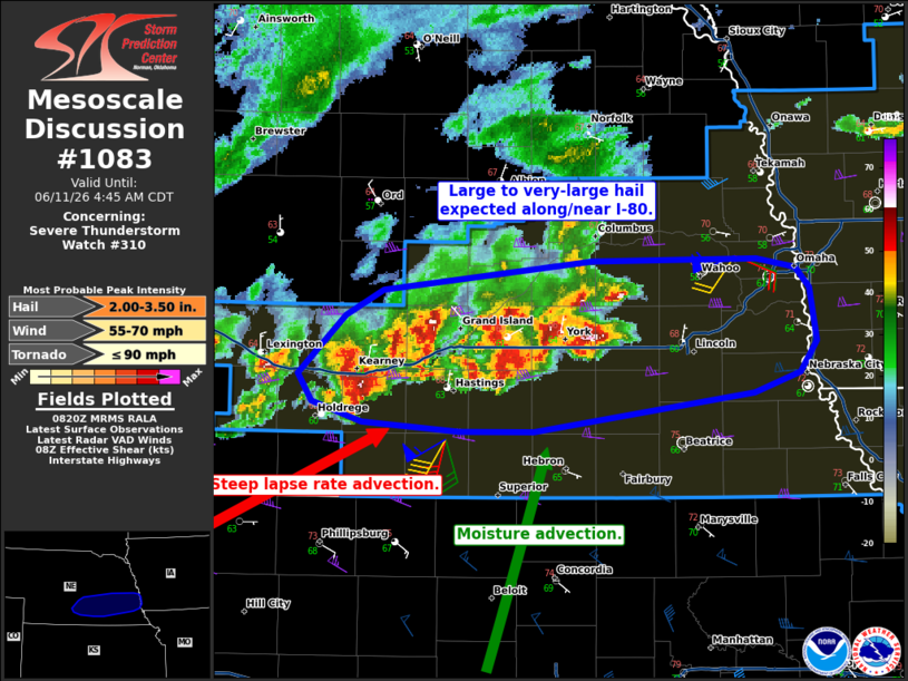
Mesoscale Discussion 1083 NWS Storm Prediction Center Norman OK 0322 AM CDT Thu Jun 11 2026 Areas affected...Southeastern Nebraska Concerning...Severe Thunderstorm Watch 310... Valid 110822Z - 110945Z The severe weather threat for Severe Thunderstorm Watch 310 continues. SUMMARY...Large to very large hail is probable along and near I-80 early this morning. DISCUSSION...A cluster of storms is ongoing from near Kearney to west of Lincoln. Storm on the southern/western end of the complex have greater potential to be supercells given the more uninhibited inflow. Several of these cells have shown 65 dBZ upwards of 30 kft with MRMS MESH indicating hail over 2 inches is possible. This cluster should generally continue eastward this morning. The environment will remain favorable for large/very-large hail and perhaps slightly improve owing to continued moisture influx at low levels. ..Wendt.. 06/11/2026 ...Please see www.spc.noaa.gov for graphic product... ATTN...WFO...OAX...GID... LAT...LON 40679950 40999915 41129889 41289739 41299621 41249593 41139582 40859578 40679590 40579622 40359780 40359834 40409903 40529940 40679950 MOST PROBABLE PEAK TORNADO INTENSITY...UP TO 90 MPH MOST PROBABLE PEAK WIND GUST...55-70 MPH MOST PROBABLE PEAK HAIL SIZE...2.00-3.50 IN |
|
|
Top/All Mesoscale Discussions/Forecast Products/Home |
|
Source link