| Mesoscale Discussion 1077 | |
| < Previous MD | |

|
|
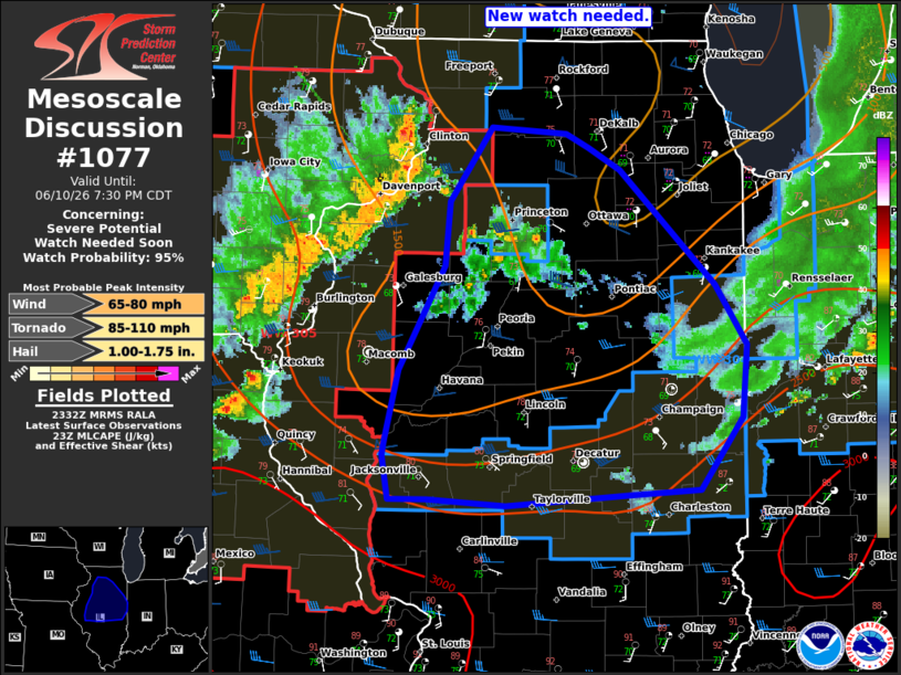
   Mesoscale Discussion 1077
   NWS Storm Prediction Center Norman OK
   0635 PM CDT Wed Jun 10 2026

   Areas affected...portions of northern Illinois

   Concerning...Severe potential...Watch needed soon

   Valid 102335Z - 110030Z

   Probability of Watch Issuance...95 percent

   SUMMARY...Storms approaching from the west will likely continue with
   a risk for damaging gusts and a tornado or two this evening. A new
   WW is likely needed shortly.

   DISCUSSION...In the wake of earlier convection, rapid air mass
   recovery is ongoing ahead of a convective line across the IA/IL
   border. This line remains strong with a recent measured severe gust
   to 60 kt at DVN. While buoyancy will be more limited (1000-2000
   J/kg), it should remain sufficient for a damaging wind risk this
   evening. A QLCS tornado or two is also possible given the strong
   low-level shear over much of northern IL. A new WW will be needed
   shortly for the expected severe threat.

   ..Lyons/Smith.. 06/10/2026

   ...Please see www.spc.noaa.gov for graphic product...

   ATTN...WFO...IND...LOT...ILX...LSX...DVN...

   LAT...LON   41488998 41958963 41918901 41828882 41688855 40958777
               40578750 40108754 39648790 39618846 39558950 39599016
               39589047 39869053 39979051 40419039 41069002 41488998

   MOST PROBABLE PEAK TORNADO INTENSITY...85-110 MPH
   MOST PROBABLE PEAK WIND GUST...65-80 MPH
   MOST PROBABLE PEAK HAIL SIZE...1.00-1.75 IN
|
|
|
Top/All Mesoscale Discussions/Forecast Products/Home |
|
Source link