| Mesoscale Discussion 107 | |
| < Previous MD | |

|
|
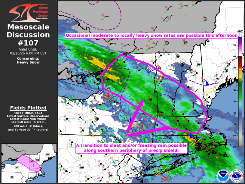
   Mesoscale Discussion 0107
   NWS Storm Prediction Center Norman OK
   1227 PM CST Fri Feb 20 2026

   Areas affected...Northern/eastern NY into parts of VT/NH/MA

   Concerning...Heavy snow

   Valid 201827Z - 202300Z

   SUMMARY...Occasional moderate to locally heavy snow rates are
   possible this afternoon. A transition to sleet and/or freezing rain
   is possible along the southern periphery of the precipitation
   shield.

   DISCUSSION...An extensive area of winter precipitation is ongoing
   early this afternoon across parts of northern/eastern NY into New
   England, with occasional observations of heavy snow noted earlier
   from Albany into parts of western MA/CT. This winter precipitation
   is occurring within a region of deep ascent driven by a favorable
   overlap of low-level warm advection and upper-level divergence, in
   advance of a vigorous mid/upper-level shortwave trough moving across
   the Great Lakes. This area of deep ascent and winter precipitation
   should continue to gradually shift northeastward through the
   afternoon.

   Low-level temperature profiles are somewhat marginal across the
   region, especially in areas of terrain-favored downslope flow.
   However, strong ascent will help to maintain snow as the primary
   precipitation types within the heavier bands, potentially resulting
   in localized snow rates approaching 1 inch per hour at times. Some
   transition to sleet and/or freezing rain will be possible along the
   southern periphery of ongoing precipitation, where ascent gradually
   weakens with time but some low-level warm advection persists.

   Later this afternoon, a cold front approaching from the west will
   allow a changeover to snow where above-freezing temperatures are
   currently observed across parts of north-central NY, near and
   downstream of Lake Ontario.

   ..Dean.. 02/20/2026

   ...Please see www.spc.noaa.gov for graphic product...

   ATTN...WFO...GYX...BOX...BTV...ALY...BGM...BUF...

   LAT...LON   42677083 42097133 42287270 42877393 43417507 43697595
               44177608 44417585 44937509 44597369 43967235 43527146
               43267111 42677083
|
|
|
Top/All Mesoscale Discussions/Forecast Products/Home |
|
Source link