| Mesoscale Discussion 106 | |
| < Previous MD | |

|
|
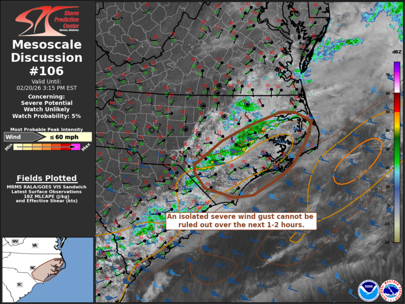
   Mesoscale Discussion 0106
   NWS Storm Prediction Center Norman OK
   1211 PM CST Fri Feb 20 2026

   Areas affected...portions of eastern North Carolina

   Concerning...Severe potential...Watch unlikely

   Valid 201811Z - 202015Z

   Probability of Watch Issuance...5 percent

   SUMMARY...A few strong convective gusts may accompany a broken band
   of convection over the next 1-2 hours, and an isolated severe gust
   cannot be ruled out.

   DISCUSSION...A broken convective band will continue to push eastward
   across portions of eastern North Carolina over the next 1-2 hours.
   Favorable low-level moisture is in place ahead of this band with
   dewpoints in the mid-60s F across the Coastal Plain; however, warm
   temperatures aloft are helping to temper available buoyancy, with
   latest mesoanalysis indicating MLCAPE of 500-1000 J/kg. Despite the
   generally limited buoyancy, modestly steep low-level lapse rates and
   strong westerly flow aloft, including 50+ kts of flow within the 1-2
   km AGL layer as sampled by the MHX VWP, will support the risk for an
   isolated severe gust over the next couple of hours. This risk will
   decrease with eastward extent as the convective band encounters an
   increasingly stable maritime air mass along the coast and nearshore
   waters.

   ..Chalmers/Mosier.. 02/20/2026

   ...Please see www.spc.noaa.gov for graphic product...

   ATTN...WFO...AKQ...MHX...RAH...ILM...

   LAT...LON   34817920 35417840 35807756 36137664 36137618 35897568
               35387588 34827626 34467676 34097744 34037802 34257889
               34657920 34817920

   MOST PROBABLE PEAK WIND GUST...UP TO 60 MPH
|
|
|
Top/All Mesoscale Discussions/Forecast Products/Home |
|
Source link