| Mesoscale Discussion 1042 | |
| < Previous MD | |

|
|
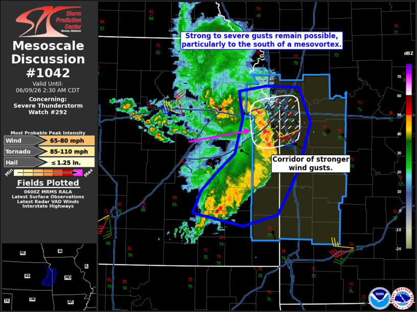
Mesoscale Discussion 1042 NWS Storm Prediction Center Norman OK 0102 AM CDT Tue Jun 09 2026 Areas affected...Portions of eastern Kansas and western Missouri Concerning...Severe Thunderstorm Watch 292... Valid 090602Z - 090730Z The severe weather threat for Severe Thunderstorm Watch 292 continues. SUMMARY...A corridor of stronger wind gusts will likely impact portions of the KC Metro area in the over the next 1-2 hours. DISCUSSION...Radar velocity data from KEAX shows a strong rear inflow jet associated with a mesovortex in the Topeka/Lawrence vicinity. This feature will continue to track slightly north of east into portions of the KC Metro area. Measured wind gusts have been less intense over the past hour than earlier in the evening, though a 60 mph gust was recently measured in Edgerton, KS. MLCAPE does gradually decline with eastward extent. That said, the strength of the MCS will likely keep some potential for strong to severe wind gusts which could produce damage at least for another hour or two. Farther south, the line of convection has been slower moving and not as intense. There remains some potential for isolated stronger wind gusts and associated damage given how warm and moist the airmass remains even to this point in the evening. ..Wendt.. 06/09/2026 ...Please see www.spc.noaa.gov for graphic product... ATTN...WFO...SGF...EAX...TOP...ICT... LAT...LON 37699605 37999592 38249566 38489535 38949522 39309529 39389482 39369428 38899409 38289429 37679463 37539521 37699605 MOST PROBABLE PEAK TORNADO INTENSITY...85-110 MPH MOST PROBABLE PEAK WIND GUST...65-80 MPH MOST PROBABLE PEAK HAIL SIZE...UP TO 1.25 IN |
|
|
Top/All Mesoscale Discussions/Forecast Products/Home |
|
Source link