| Mesoscale Discussion 1011 | |
| < Previous MD | |

|
|
Mesoscale Discussion 1011
NWS Storm Prediction Center Norman OK
0758 PM CDT Sat Jun 06 2026
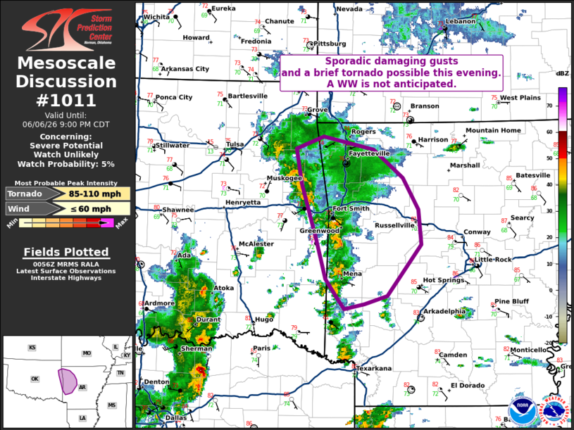
Areas affected...lfar eastern Oklahoma and western Arkansas
Concerning...Severe potential...Watch unlikely
Valid 070058Z - 070200Z
Probability of Watch Issuance...5 percent
SUMMARY...Locally enhanced low-level shear could support sporadic
damaging gusts or a brief tornado with a band of thunderstorms this
evening. Broader organization is unlikely and a Watch is not
expected.
DISCUSSION...Early evening radar imagery showed a band of storms had
developed near a remnant MCV across portions of far eastern OK and
western AR. A very moist environment is in place with dewpoints in
the 70s F. This is supporting low cloud bases and moderate buoyancy
with MLCAPE of 1500-2000 J/kg. Locally backed low-level flow near
the MCV is enhancing low-level shear with the SRX VAD showing
100-200 m2/s2 of ESRH. This is supporting weak storm-based rotation
within the band of storms. While the lack of broader ascent and
deep-layer shear should keep storm organization limited/transient,
sporadic damaging gusts and a brief tornado are possible over the
next couple of hours. Given the short duration and local risk, a WW
is not expected.
..Lyons/Gleason.. 06/07/2026
...Please see www.spc.noaa.gov for graphic product...
ATTN...WFO...LZK...SHV...TSA...
LAT...LON 35069461 35759484 36179491 36339450 36169375 35829332
35429309 35009304 34379356 34269389 34219420 34309427
34589448 35069461
MOST PROBABLE PEAK TORNADO INTENSITY...85-110 MPH
MOST PROBABLE PEAK WIND GUST...UP TO 60 MPH
|
|
|
Top/All Mesoscale Discussions/Forecast Products/Home |
|
Source link