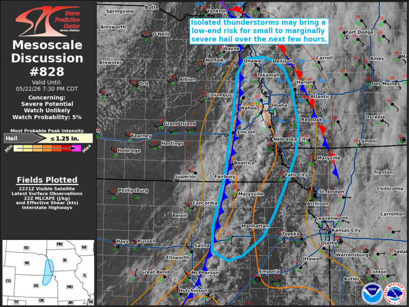
MD 0828 CONCERNING SEVERE POTENTIAL…WATCH UNLIKELY FOR PORTIONS OF THE MID-MISSOURI VALLEY
Mesoscale Discussion 0828
NWS Storm Prediction Center Norman OK
0524 PM CDT Fri May 22 2026

Areas affected...portions of the mid-Missouri Valley

Concerning...Severe potential...Watch unlikely

Valid 222224Z - 230030Z

Probability of Watch Issuance...5 percent

SUMMARY...Isolated thunderstorms forming along/ahead of an
approaching cold front may bring a low-end risk for small to
marginally severe hail over the next few hours. Watch issuance is
not expected.

DISCUSSION...Latest radar imagery depicts modest deepening of a
low-topped thunderstorm south of the Omaha, Nebraska, vicinity, with
additional thunderstorm activity noted within a narrow corridor of
weak buoyancy (500-1000 J/kg MLCAPE per latest objective analysis).
While mid-level flow remains modest at best, as sampled by the OAX
VWP, 25-35 kts of effective bulk shear may support some organization
of stronger updrafts, with marginal/transient supercells possible.
While relatively warm mid-level temperatures (sampled above 600 mb
per a recent OAX ACARS profile) and generally weak mid-level lapse
rates (6-6.5 C/km sampled by the 18z OAX observed sounding) are
likely to temper overall updraft intensity, a low-end risk for small
to marginally severe hail may accompany the strongest updrafts. This
potential appears to decrease with southward extent into
northeastern Kansas where effective shear is lower (less than 25
kts). Given the limited nature of severe coverage/magnitude, watch
issuance is not expected.

..Chalmers/Thompson.. 05/22/2026

...Please see www.spc.noaa.gov for graphic product...

ATTN...WFO...DMX...EAX...OAX...TOP...

LAT...LON   38649683 38819719 39249717 40099692 41209673 41849666
            42109648 42149607 42089580 41929557 41609540 40959526
            40479532 39919557 39459581 39049606 38739652 38649683

MOST PROBABLE PEAK HAIL SIZE...UP TO 1.25 IN
Source link