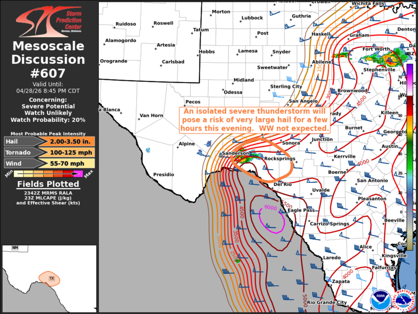
MD 0607 CONCERNING SEVERE POTENTIAL…WATCH UNLIKELY FOR SOUTHWEST TEXAS
Mesoscale Discussion 0607
NWS Storm Prediction Center Norman OK
0644 PM CDT Tue Apr 28 2026

Areas affected...Southwest Texas

Concerning...Severe potential...Watch unlikely

Valid 282344Z - 290145Z

Probability of Watch Issuance...20 percent

SUMMARY...An isolated severe thunderstorm will pose a risk of large
hail for a couple of hours over parts of southwest Texas.  A watch
is not anticipated.

DISCUSSION...An isolated intense thunderstorm has formed in Terrell
county TX, just east of Sanderson.  This cell formed along the
surface dryline in a very hot/moist and unstable air mass.  This
storm will likely persist for a couple of hours, tracking into Val
Verde county.  Left-splits from this cell could affect southern
Crockett county as well.  Very steep mid-level lapse rates, high
CAPE, and supercell structures will continue to pose a risk of large
hail over 2 inches and locally damaging wind gusts.  Coverage of
storms is expected to remain sparse, so a watch is not currently
anticipated.

..Hart/Mosier.. 04/28/2026

...Please see www.spc.noaa.gov for graphic product...

ATTN...WFO...EWX...SJT...MAF...

LAT...LON   30370191 30600122 30170043 29790035 29610064 29530113
            29890192 30140208 30370191

MOST PROBABLE PEAK TORNADO INTENSITY...100-125 MPH
MOST PROBABLE PEAK WIND GUST...55-70 MPH
MOST PROBABLE PEAK HAIL SIZE...2.00-3.50 IN
Source link