

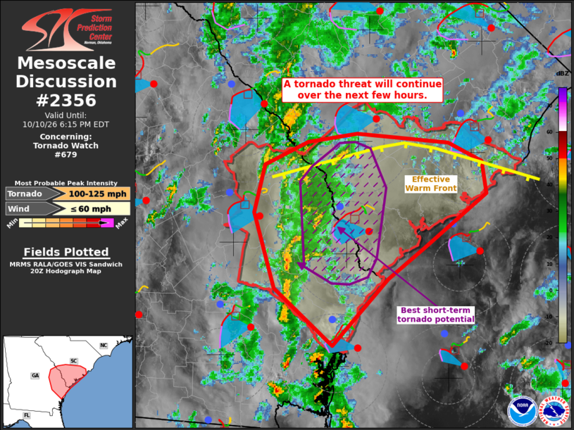
MD 2356 CONCERNING TORNADO WATCH 679… FOR PORTIONS OF FAR EASTERN GEORGIA INTO CENTRAL AND SOUTHERN SOUTH CAROLINA
Mesoscale Discussion 2356
NWS Storm Prediction Center Norman OK
0352 PM CDT Sat Oct 10 2026

Areas affected...portions of far eastern Georgia into central and
southern South Carolina

Concerning...Tornado Watch 679...

Valid 102052Z - 102215Z

The severe weather threat for Tornado Watch 679 continues.

SUMMARY...Isolated tornadoes will remain a concern through the rest
of the afternoon. A strong tornado still cannot be ruled out.

DISCUSSION...At least 2 supercell structures embedded within the
primary confluence zone along the GA/SC have been tornadic, with
multiple tornadoes observed. Other storm structures in the
confluence band have attempted to organize into supercells south of
Screven County GA, but have failed to produce notable low-level
rotation so far based on KCLX radar data. Despite the seemingly
downward convective trends, the parent confluence band continues to
progress east-northeast toward an ambient airmass characterized by
mid to upper 70s temperatures and dewpoints, yielding over 1500 J/kg
MLCAPE. Furthermore, the CAE and CLX VADs show large, curved
low-level hodographs and 300-500 m2/s2 0-3 km SRH, with around 200
m2/s2 SRH in the 0-1 km layer. This combined buoyancy/low-level
shear profile is highly favorable for additional tornadoes under the
condition that a supercell structure can develop.

..Squitieri.. 10/10/2026

...Please see www.spc.noaa.gov for graphic product...

ATTN...WFO...CHS...CAE...FFC...

LAT...LON   31368142 31918207 32638230 33098218 33328169 33408114
            33318009 33127971 32817967 32288039 31998078 31368142

MOST PROBABLE PEAK TORNADO INTENSITY...100-125 MPH
MOST PROBABLE PEAK WIND GUST...UP TO 60 MPH
Source link