

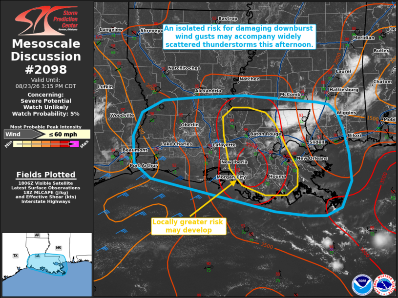
MD 2098 CONCERNING SEVERE POTENTIAL…WATCH UNLIKELY FOR PORTIONS OF THE CENTRAL GULF COAST
Mesoscale Discussion 2098
NWS Storm Prediction Center Norman OK
0112 PM CDT Sun Aug 23 2026

Areas affected...portions of the central Gulf Coast

Concerning...Severe potential...Watch unlikely

Valid 231812Z - 232015Z

Probability of Watch Issuance...5 percent

SUMMARY...Widely scattered thunderstorms may pose a risk for
isolated damaging wind gusts through this afternoon and evening.
Watch issuance is not anticipated.

DISCUSSION...Latest objective analysis indicates MLCAPE has
increased to 2000-3500 J/kg across portions of the central Gulf
Coast/lower Mississippi River Valley amid a hot/humid low-level air
mass, which is also supported by a modified 12 UTC sounding from
LIX. While low-level flow remains relatively weak (less than 20 kts
sampled below 4 km AGL by regional VWPs), PW around 1.75 inches and
steepening low-level lapse rates amid moderate to strong buoyancy
should support a risk for isolated damaging wind gusts with any
stronger microbursts. The greatest potential may exist/develop
across portions of south-central Louisiana where current
observations/guidance suggest a locally more favorable thermodynamic
environment for downbursts may exist (as supported by microburst
composite parameter values of 7-8 per latest mesoanalysis). The
overall risk is forecast to remain isolated in nature and limited in
magnitude, however, which should preclude the need for a watch.

..Chalmers/Smith.. 08/23/2026

...Please see www.spc.noaa.gov for graphic product...

ATTN...WFO...MOB...JAN...LIX...LCH...

LAT...LON   28949056 29599341 29899379 30459383 30939364 31189315
            31249234 31289125 31188995 31158959 31108930 30938910
            30608896 30108884 29558878 29028902 28868938 28868979
            28949056

MOST PROBABLE PEAK WIND GUST...UP TO 60 MPH
Source link