

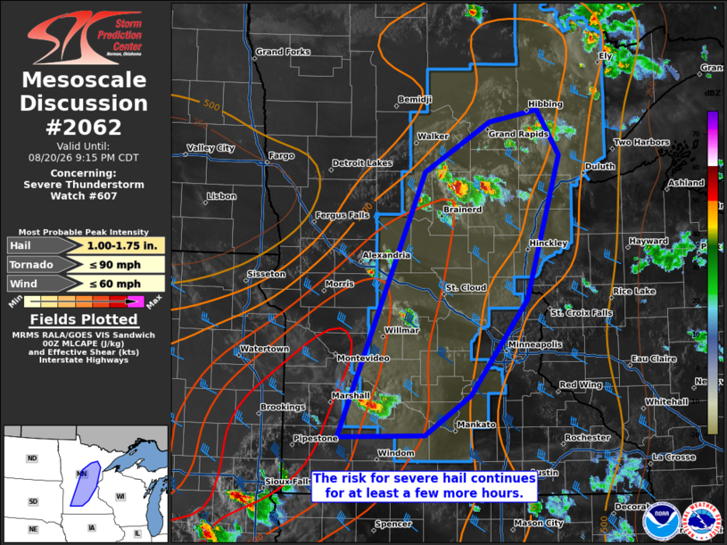
MD 2062 CONCERNING SEVERE THUNDERSTORM WATCH 607… FOR MUCH OF CENTRAL MINNESOTA
Mesoscale Discussion 2062
NWS Storm Prediction Center Norman OK
0746 PM CDT Thu Aug 20 2026

Areas affected...much of central Minnesota

Concerning...Severe Thunderstorm Watch 607...

Valid 210046Z - 210215Z

The severe weather threat for Severe Thunderstorm Watch 607
continues.

SUMMARY...Severe hail remains a concern with the stronger sustained
supercells this evening.

DISCUSSION...Multiple sustained supercells have progressed across
central MN over the past few hours, with marginally severe hail
reported (particularly with the storms over northern MN). 2000-3000
J/kg MLCAPE remains in place, along with 35-40 kts of effective bulk
shear per 00Z mesoanalysis. The 00Z MPX observed sounding also shows
a hodograph with appreciable low-level curvature and modest
elongation, suggesting that supercells will remain the dominant mode
of the convection through the evening hours. Large hail should
remain the primary threat, though a damaging gust or tornado cannot
be ruled out.

..Squitieri.. 08/21/2026

...Please see www.spc.noaa.gov for graphic product...

ATTN...WFO...DLH...MPX...FSD...

LAT...LON   44089567 46809443 47319349 47429279 46979247 45499294
            44519376 44119442 44089567

MOST PROBABLE PEAK TORNADO INTENSITY...UP TO 90 MPH
MOST PROBABLE PEAK WIND GUST...UP TO 60 MPH
MOST PROBABLE PEAK HAIL SIZE...1.00-1.75 IN
Source link