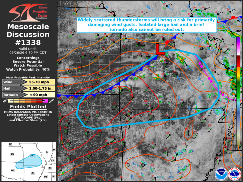
MD 1338 CONCERNING SEVERE POTENTIAL…WATCH POSSIBLE FOR PORTIONS OF NORTHEASTERN OKLAHOMA AND SOUTHEASTERN KANSAS INTO SOUTHERN MISSOURI AND NORTHERN ARKANSAS
Mesoscale Discussion 1338
NWS Storm Prediction Center Norman OK
0455 PM CDT Fri Jun 26 2026

Areas affected...portions of northeastern Oklahoma and southeastern
Kansas into southern Missouri and northern Arkansas

Concerning...Severe potential...Watch possible

Valid 262155Z - 262330Z

Probability of Watch Issuance...40 percent

SUMMARY...Widely scattered thunderstorms will pose a risk for
primarily damaging wind gusts through this evening. Isolated large
hail and perhaps a brief tornado are also possible.

DISCUSSION...Recent visible satellite imagery and GOES lightning
data depicts an uptick in convective activity along a surface cold
front extending from far southeastern Kansas into central Missouri.
While effective shear remains only marginally supportive of
organized convection (20-30 kts per latest mesoanalysis),
loosely-organized clusters and perhaps marginal supercell structures
will be possible. Moderate to strong buoyancy (ranging from 1500
J/kg MLCAPE in central/southeastern Missouri up to 3500 J/kg in
northeastern Oklahoma) and a very moist environment (dewpoints in
the mid-70s F and PWAT of 1.75-2.0+ inches) will promote a risk for
water-loaded downdrafts and isolated damaging wind gusts. Isolated
large hail may also occur with the most robust updrafts, especially
farther west into Oklahoma where mid-level lapse rates are modestly
steeper. A brief tornado also cannot be ruled out given moderate to
strong low-level buoyancy overlapping ambient surface vertical
vorticity in the vicinity of the surface front and a remnant outflow
boundary.

..Chalmers/Mosier.. 06/26/2026

...Please see www.spc.noaa.gov for graphic product...

ATTN...WFO...PAH...MEG...LSX...LZK...SGF...TSA...ICT...

LAT...LON   37349538 37919399 38139352 38499281 38559246 38559201
            38389126 38119090 37749062 37319030 36909029 36519064
            36199170 35909470 35789570 35879610 36259644 36619638
            36989608 37349538

MOST PROBABLE PEAK TORNADO INTENSITY...UP TO 90 MPH
MOST PROBABLE PEAK WIND GUST...55-70 MPH
MOST PROBABLE PEAK HAIL SIZE...1.00-1.75 IN
Source link