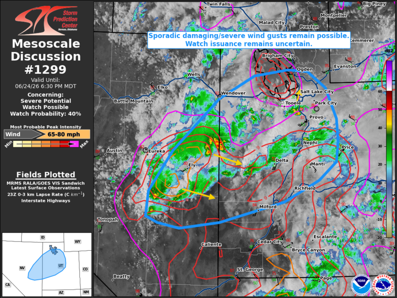
MD 1299 CONCERNING SEVERE POTENTIAL…WATCH POSSIBLE FOR PORTIONS OF THE GREAT BASIN
Mesoscale Discussion 1299
NWS Storm Prediction Center Norman OK
0606 PM CDT Wed Jun 24 2026

Areas affected...portions of the Great Basin

Concerning...Severe potential...Watch possible

Valid 242306Z - 250030Z

Probability of Watch Issuance...40 percent

SUMMARY...Scattered, high-based convection continues to pose a risk
for sporadic damaging/severe wind gusts. Watch issuance remains
uncertain.

DISCUSSION...Widely scattered to scattered, high-based thunderstorms
have developed from eastern Nevada into central Utah ahead of an
approaching mid-level shortwave trough as of late afternoon. A deep,
well-mixed boundary layer and inverted-v thermodynamic profiles, as
sampled by the 18 UTC SLC observed sounding, are favoring efficient
evaporative cooling and downdraft accelerations, with several
reports of 60+ mph wind gusts already received. Over the next 1-2
hours, ongoing convection south of the greater Salt Lake City area
may spread northward with a continued threat for occasional
damaging/severe wind gusts. Additionally, recent high-res guidance
suggests that some cold pool consolidation may occur with the more
scattered convection noted across eastern Nevada, with the resultant
loosely-organized cluster/band then developing east-southeastward.
Should this scenario unfold, a locally greater risk for severe wind
gusts may evolve across portions of western Utah in association with
this convection. Despite this potential, relatively weak flow
sampled below 5-6 km AGL by the MTX/LRX VAD profiles may preclude a
greater coverage of severe wind gusts. This continues to lend
uncertainty to the need for a Severe Thunderstorm Watch.

..Chalmers/Mosier.. 06/24/2026

...Please see www.spc.noaa.gov for graphic product...

ATTN...WFO...SLC...VEF...LKN...

LAT...LON   38771590 39601528 40681404 41151310 41281219 41241166
            40901117 40251089 39781086 39371092 39001138 38551232
            38131402 38011508 38121565 38251595 38771590

MOST PROBABLE PEAK WIND GUST...65-80 MPH
Source link