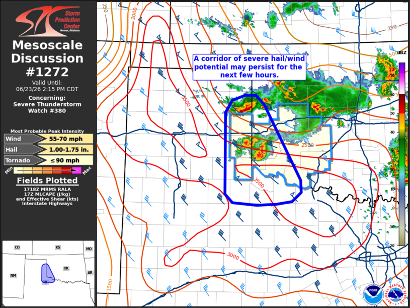
MD 1272 CONCERNING SEVERE THUNDERSTORM WATCH 380… FOR WESTERN OKLAHOMA INTO NORTHWEST TEXAS AND THE FAR EASTERN TEXAS PANHANDLE
Mesoscale Discussion 1272
NWS Storm Prediction Center Norman OK
1221 PM CDT Tue Jun 23 2026

Areas affected...Western Oklahoma into northwest Texas and the far
eastern Texas Panhandle

Concerning...Severe Thunderstorm Watch 380...

Valid 231721Z - 231915Z

The severe weather threat for Severe Thunderstorm Watch 380
continues.

SUMMARY...A corridor of higher severe hail and wind potential may
persist for the next few hours as storms begin to approach the Red
River. Local expansion of WW 380 may be needed.

DISCUSSION...Over the past hour, an initial line of thunderstorms
has devolved into a pair of loosely organized supercells. Based on
recent MRMS data, these cells remain capable of producing large hail
with at least a couple of reports of one-inch hail noted over the
past 1-2 hours. Latest high-res guidance continues to handle this
convection poorly, which casts some uncertainty onto storm evolution
into the mid/late afternoon hours. However, these cells are
approaching the regional buoyancy axis where MLCAPE is increasing to
near 3000 J/kg. Latest VWP observations from KFDR sampled 0-6 km BWD
values on the order of 25-30 knots, which is slightly lower than
depicted by recent mesoanalyses (30-35 knots). Given a downstream
environment with increasing buoyancy but slightly diminishing
mid-level flow/deep-layer wind shear with southward extent, some
uptick in updraft intensity appears likely, but it is unclear how
well-organized convection will be beyond the next couple of hours.
Nonetheless, some local extensions of WW 380 will be necessary as
storms approach the Red River.

..Moore.. 06/23/2026

...Please see www.spc.noaa.gov for graphic product...

ATTN...WFO...OUN...LUB...AMA...

LAT...LON   35630064 35880047 35970017 35989990 35809970 34289883
            34059881 33869903 33819940 33809987 33840045 34010063
            35630064

MOST PROBABLE PEAK TORNADO INTENSITY...UP TO 90 MPH
MOST PROBABLE PEAK WIND GUST...55-70 MPH
MOST PROBABLE PEAK HAIL SIZE...1.00-1.75 IN
Source link