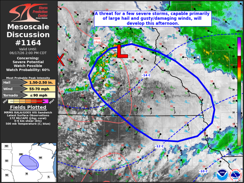
MD 1164 CONCERNING SEVERE POTENTIAL…WATCH POSSIBLE FOR PORTIONS OF THE UPPER MISSISSIPPI RIVER VALLEY
Mesoscale Discussion 1164
NWS Storm Prediction Center Norman OK
1237 PM CDT Wed Jun 17 2026

Areas affected...portions of the upper Mississippi River Valley

Concerning...Severe potential...Watch possible

Valid 171737Z - 171900Z

Probability of Watch Issuance...60 percent

SUMMARY...A few severe thunderstorms will develop from portions of
southeastern Minnesota into northeastern Iowa and southwestern
Wisconsin this afternoon, with a threat for primarily large hail and
strong/damaging wind gusts.

DISCUSSION...Regional radar imagery depicts increasing thunderstorm
activity in close proximity to a surface low analyzed west of
Minneapolis, MN, and immediately downstream of a potent mid-level
shortwave trough. Cold mid-level temperatures and ascent preceding
this feature are coupling with modest surface heating to support
weak destabilization (500 J/kg MLCAPE), with 500-1000 J/kg expected
by peak heating this afternoon. Very strong westerly mid-level flow
(70+ kts sampled at 4 km AGL by the DMX/ARX VAD profiles) is
contributing 40-50+ kts of effective shear, supportive of supercell
development. While mid-level lapse rates are forecast to remain
modest (6-6.5 C/km), this strong shear and elongated, relatively
straight hodographs will promote large hail as the primary severe
risk, with a localized instance or two of hail to 2" in diameter
possible pending the development of a sustained supercell.
Strong/damaging wind gusts are also possible owing to downward
momentum transport of strengthening low-level flow within
downdrafts. A brief tornado also cannot be ruled out owing to the
overlap between increasing low-level buoyancy and enhanced surface
vertical vorticity in close proximity to the aforementioned surface
low. A Severe Thunderstorm Watch may be needed in the next 1-2 hours
to cover these threats.

..Chalmers/Hart.. 06/17/2026

...Please see www.spc.noaa.gov for graphic product...

ATTN...WFO...ARX...MPX...DMX...

LAT...LON   45089430 45199356 45019268 44809211 44389138 43979096
            43639084 43319093 43009142 42889205 42929285 43209342
            43669420 43849448 44139483 44449497 44849470 45089430

MOST PROBABLE PEAK TORNADO INTENSITY...UP TO 90 MPH
MOST PROBABLE PEAK WIND GUST...55-70 MPH
MOST PROBABLE PEAK HAIL SIZE...1.50-2.50 IN
Source link