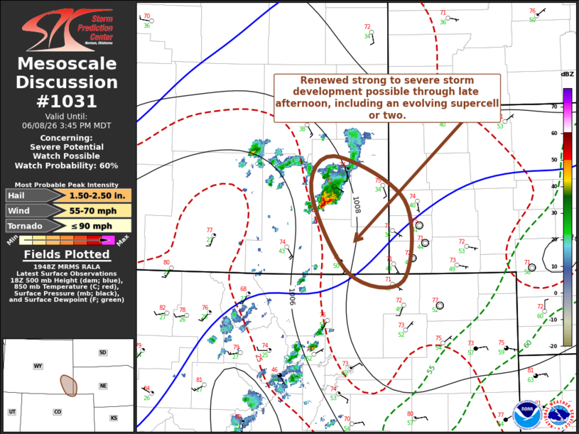
MD 1031 CONCERNING SEVERE POTENTIAL…WATCH POSSIBLE FOR PARTS OF SOUTHEASTERN WYOMING AND ADJACENT NORTHEASTERN COLORADO/SOUTHWESTERN NEBRASKA
Mesoscale Discussion 1031
NWS Storm Prediction Center Norman OK
0251 PM CDT Mon Jun 08 2026

Areas affected...parts of southeastern Wyoming and adjacent
northeastern Colorado/southwestern Nebraska

Concerning...Severe potential...Watch possible

Valid 081951Z - 082145Z

Probability of Watch Issuance...60 percent

SUMMARY...Renewed isolated supercell development possible through
late afternoon.  Trends are being monitored for the possibility of a
severe weather watch.

DISCUSSION...Isolated vigorous thunderstorm development is already
underway near/north of the Cheyenne Ridge, likely supported by
inflow emanating from a narrow corridor of low-level moistening
along the Front Range into southeastern Wyoming.  Although warming
mid-levels and slower low-level moisture to the east of the higher
terrain may initially inhibit eastward propagation of stronger
convection, upslope flow into the higher terrain near/east of
Cheyenne may provide a focus for renewed strong to severe
thunderstorm development through late afternoon.  Beneath modest,
but strongly sheared, southwesterly deep-layer mean flow, this may
include an evolving supercell or two accompanied by the risk for
large hail.

..Kerr/Smith.. 06/08/2026

...Please see www.spc.noaa.gov for graphic product...

ATTN...WFO...BOU...CYS...

LAT...LON   42410493 41880380 40920382 41010469 41980529 42410493

MOST PROBABLE PEAK TORNADO INTENSITY...UP TO 90 MPH
MOST PROBABLE PEAK WIND GUST...55-70 MPH
MOST PROBABLE PEAK HAIL SIZE...1.50-2.50 IN
Source link